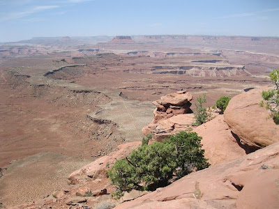
The Murphy Point Overlook Trail is located in the Island of the Sky District of Canyonlands National Park in southeast Utah. The trailhead is on the west side of the main park road, south of the junction with the west leading Upheaval Dome road.
The trailhead sign says it is 1.8 miles to the overlook, or a 3.6 mile round trip. The Murphy Trail branches off to the left after 0.5 miles and leads down to the White Rim Road via two different routes.
The first segment of trail looks like an old road and passes through a pasture like area. There is an old corral along the way. The vegetation changes gradually from the grassland, to a mix Mormon Tea and Blackbrush, and then to rocky Pinon and Juniper desert vegetation.
The best wildflower I saw along the first segment was a cactus. This one happened to have a small lizard climbing on it. There were many of these small lizards along this segment.
About two-thirds of the way to the overlook, there are some views to the west toward the Candlestick Tower. Some of the narrow finger-looking canyons that are visible from the Grand View Point appear here also. As the terrain changes from pasture to rocky desert, the trail becomes a route marked with rock cairns.
There are also some glimpses of the Green River. The formation known as the Turk’s Head is visible in the area where the Green River makes a loop.
At the overlook, there are some of the wide spectacular views for which Canyonlands is famous. I think the formation below to the southwest is called the Murphy Hogback and one of the two branches of the Murphy Trail is visible.
Looking to the southeast, Grand View Point is visible to the left with Junction Butte to the right. My hike for 3.6 miles took 1:30 hours on a 68 F degree early May day. I only saw 5 other hikers on an otherwise busy day weekend day.


No comments:
Post a Comment