Showing posts with label Canyon Rims Recreation Area. Show all posts

Tuesday, October 23, 2012

Trough Springs Trail in Canyon Rims


The Trough Springs Trail is a 2.5 mile historic cattle trail in Canyon Rims Recreation Area, a large mesa top area to the east of Canyonlands National Park in southeast Utah. 

The Hatch Point District of Canyon Rims is about 32 miles south of Moab along Highway 191 in southeast Utah. The marked entry road is north of the Route 211 entry road to the Needles District of Canyonlands.


The trail head is at the end of a short dirt road in the north end of the Canyon Rims area, near the Anticline Overlook Trail. There are many dirt road opportunities and short overlook point trails for hiking in Canyon Rims but this appears to be the only actual hiking trail.


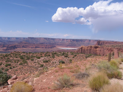
The trail descends 1100 feet to a junction with Kane Creek Canyon. The terrain here is scattered Pinon Pine and Utah Juniper trees, Single Leaf Ash, Black Brush, Cactus, and Mormon Tea along dry rocky washes. The trail is well marked with rock cairns.

The La Sal Mountains are visible to the east. The trail dates from the early 1900s and was used to move stock from the canyon rim to the Kane Creek Canyon below.


As the trail descends the massive Navajo and Wingate sandstone cliffs common in the region appear. The first segment of trail is a gradual descent with wide views.


After about 0:40 minutes and 1.3 miles the trail becomes more dramatic as it descends steeply into the Trough Springs Canyon. The route passes below the steep Wingate Sandstone and enters the rugged Chinle layer.


The trial crosses around the head of the canyon and descends mostly on the west side. This segment is similar to the trails in the Island of the Sky District of Canyonlands as you have to watch for the cairns and step carefully.  


It took me 0:40 minutes to descend along this steep segment, 1:20 hours total to arrive at the canyon floor. There was water flowing at the bottom and a thick growth of Cottonwoods and Willows.


Except for a few vague spots the walking toward Kane Creek Canyon was easy along a route that seemed like a cow trail. Since there was water here I kept an eye out for ruins sites and petroglyphs but didn't notice anything. The flowing water seems to be reabsorbed into the creek bed. I didn't see any flow toward the junction with Kane Creek.


didn't try to cross the wide eroded wash at the end of the trail. The 4WD trail along Kane Creek is visible here on the other side, and I saw two vehicles pass by. It took me about 2:00 hours to arrive at this junction.


My return hike took 2:25 hours for a total hike of 4:35 hours for 5 miles. The steep segment took me 1:00 hour to climb after taking 0:40 minutes to descend. I carried and drank 3 liters of water on a 65 F degree late October day. 


Thursday, January 5, 2012

Horsehead Rock in Canyon Rims

The Hatch Point area of the Canyon Rims Recreation Area is a large mesa top area that lies to the east of the Needles District of Canyonlands National Park in southeast Utah. Horsehead Rock is one of the large rock outcrops rising above the sagebrush and Pinon Juniper forest area.

The Highway 191 turnoff for Canyon Rims is about 32 miles south of Moab, UT and a few miles north of the turnoff for the Needles District of Canyonlands. About 16 miles along the paved road there is a junction with the paved road staying left leading to the developed Needles Overlook.

I started my hike toward Horsehead rock about 2.6 miles past the junction at San Juan County Road 169, a well maintained dirt road. The terrain along Road 169 is mostly level through sagebrush fields with good views east toward the LaSal Mountains.

 After 1.7 miles there is short side trail to the east that leads to an overlook of Horsehead Rock. I didn’t see a trail that leads all the way but it looks like hiking through the forest would be feasible. I saw a ranching artifact along this side trail. I kept an eye out for Pronghorn Antelope while hiking but didn’t see any. There are a few cows grazing in the Hatch Point area.

The main road descends into a wide valley with some views of the LaSal Mountains and Horsehead Rock in alignment. The elevation of Horsehead Rock is 6191 feet. The Pinon and Juniper Forest gets thicker as the trail proceeds north. At 3 miles there is a junction with County Road 170. Continuing north on 169 it is another 0.8 miles to the mesa top rim. Road 170 turns west and also leads to the rim after 2.2 miles. Road 170 leads closer to the formation that is called Hatch Point.

Road 169 ends at the rim and there are wide views north over Lockhart Basin. This is the terrain that is visible from the Needles Overlook and some of the other viewpoints in the Hatch Point area. The Colorado River winds through the area below but I couldn’t see it from this angle.


It took me 1:30 hours to arrive at the overlook. Without the side trail the main road distance is 3.8 miles. The return hike took 1:15 hours. My total hike took 3:00 hours for about 8 miles on a 44 F degree mild early January day. I didn’t see anyone else on this route while I was hiking. There were a few other vehicles in the area, including a few heavy trucks at a drilling site.

Wednesday, February 23, 2011

Boxcar Bridge Trail in Canyon Rims

The Boxcar Bridge Trail is located in the Hatch Point District of the Canyon Rims Recreation Area in southeast Utah. The Canyon Rims area covers a large area to the east of Canyonlands National Park. The Boxcar Bridge route isn’t pointed out with signs but is mentioned on maps and guidebooks as a mountain bike route.
I started my hike 20.5 miles along County Road 133/132 from the junction with Highway 191, the access road for the Hatch Point area. This is past the turn off to the spectacular Needles Overlook Trail and the road changes from paved to gravel. There is a wide spot in the road at this point and a sign that says “View Point” with views both west toward the Canyonlands area and east toward the LaSal Mountains. The trail is a 4WD road that leads east through a wide field of sagebrush.

After about 30 minutes of hiking, the trail begins to descend into Trout Water Canyon and leads to an area with Cottonwood trees and some ranching artifacts. In the Sagebrush fields and in the canyon, I kept an eye out for Pronghorn Antelopes, which are supposed to live in the Hatch Point area, but I didn’t see any. Pronghorns are known for their keen eyesight and extreme speed. They are opportunistic, feeding on grasses, shrubs, and trees. It took me 1:10 hours to arrive at the canyon floor.

A few minutes of hiking further, there is a trail junction with the left fork leading further down Trout Water Canyon and the right fork climbing to the south rim. I followed the right fork and climbed to the mesa top area. In late February, there were small patches of snow in shady spots but the trail was mostly dry and walking easy.
The view further down Trout Water Canyon shows several alcoves in the sandstone walls. The interpretive information for the Canyon Rims area says that most of the sandstone outcrops visible here are Navajo sandstone. Ancestral Pueblo people are thought to have occupied the area for a short time, ending in the mid 1200s. It seems like this canyon area, with a spring and alcoves would be a place to search for ruins and rock art. I scanned the alcoves from a distance for ruins structures but didn’t see anything.
 
On the mesa top area there is another trail junction with a view of a large sandstone butte. On the nearest corner there is a formation that appears to be an arch or window, the Boxcar Bridge. I followed both trail forks for a few hundred yards and the best views are from the right fork. The main trail continues along the left fork. I couldn’t find Boxcar Bridge mentioned in the on line guides to arches so perhaps there is a gap and it isn't actually an arch. The view is from a long distance and it would take a lot of walking and climbing to get a close view.

I turned around here and retraced my steps. My total hike was 4:30 hours for about 8.5 miles. It was 36 F degrees at 10:30 AM when I started and 43 F at 3:00 PM at the finish. On a cool day I carried and drank 2 liters of water.

Canyonlands Erosion from the Needles Overlook

The Hatch Point District of the Canyon Rims Recreation Area features several spectacular overlooks of the eroded rocks east of Canyonlands National Park in southeast Utah. The Needles Overlook is 22 miles along paved County Road 133 from the junction with Highway 191, between Moab and Monticello, Utah.


There is a short system of trails at the Needles Overlook. The view to the north is toward Hatch Point. An Interpretive sign lists the geologic layers visible her as starting at the top with Navajo and Kayenta sandstone. I think these are missing at the tip of Hatch Point but are visible back to the east. The massive cliffs are the Wingate sandstone, and below are the softer Chinle, Moenkopi and Cutler layers.
 
Slightly west of Hatch Point there are glimpses of the Colorado River. An interpretive sign explaining erosion mentions the power of a raindrop, exploding like a bomb on loose soil particles. Flowing water from flash floods runs off quickly and carries these small grains away.

Freezing and thawing during the winter wedges rock chunks apart. Water flowing in the Colorado and Indian Creek below undercuts rock material as it turns the bends, causing it to crash and get carried away.

The area below the Needles Overlook is called the Lockhart Basin area and can be visited along the 4WD road that turns north a few miles east of the entrance to the Needles District of Canyonlands Park. Hikers can start at the Indian Creek crossing and continue to the area below the Needles Overlook and find Pelican Arch and some Ancestral Pueblo rock art.


532497_120 x 90 Starting Salary $42k. Group 1

Thursday, June 18, 2009

Aqueduct Arch Trail

The Aqueduct Arch Trail starts about 11.2 miles north along Harts Point Road in the Canyon Rims Recreation Area in southeast Utah and is not marked. The Harts Point area is between Canyonlands Park and Indian Creek to the west and the Hatch Point district of Canyon Rims to the east.

The Harts Point Road is about 12 miles west along Utah Route 211 on the way to the Needles District of Canyonlands Park. This area is wild and remote canyon country with no facilities for visitors.

There is a two track 4WD road leading east off of the graded road for about 2.2 miles from the unmarked trail head, then a right turn that leads for a short distance and the road ends. The walking along the slightly sandy road is easy and there are good canyon views to the east toward the La Sal Mountains.

The end of the road overlooks a side canyon of Harts Draw. The arch is near the bottom of the main part of this side canyon, and is not visible from the end of the road.

There are some hiker cairns leading down through a cliff area and then the route follows a small drainage to the canyon rim. The arch is visible toward the east side. There are more rock cairns leading down from the rim into a side canyon that allow a closer view. I went down to the next main shelf below the rim and stopped there.

The route continues further down into the canyon but appears to get more difficult. Aqueduct Arch looks like it was once a large deep alcove and the roof collapsed. There are other similar alcoves that are visible in the area. I scanned with binoculars for Ancestral Pueblo ruins in the alcoves but didn’t spot anything.

It took me about 0:45 minutes to get to the end of the 4WD road and I hiked another 30 minutes to the rim and somewhat down into the canyon. It was a relatively cool 70 F mid June day and I carried two liters of water. My total hike was 2:40 hours. Nearby to the Aqueduct Arch route is a shorter hike to Mug Handle Arch. The Chris Moore Guide to Natural Arches in the Moab Area is very helpful for finding these large spectacular arches.

Wednesday, June 17, 2009

Mug Handle Arch Trail

The Mug Handle Arch Trail is in the Harts Point section of the Canyon Rims Recreation Area in southeast Utah. The Harts Point Area is a mesa top that overlooks the east side of the Indian Creek corridor that leads to the Needles District of Canyonlands National Park.

About 12 miles along Utah scenic route 211 there is a sign pointing out Harts Draw Road to the south. The road to Harts Point is the north leading part of the same road. The Harts Point area doesn't have any visitor facilities. I started my hike 11.6 miles along this graded road next to an old windmill on the west side. The turbine for the windmill is in ruins on the ground and has been there so long a sage brush is growing up though it.

The unmarked trail to Aqueduct Arch begins in this same vicinity. The terrain here is scattered Pinon Pines and Utah Junipers with areas where sage brush dominates. There is good canyon country in the Harts Point area, but not the spectacular view points that are the highlight of the more developed Hatch Point area of Canyon Rims.

From the old windmill I walked about 5 minutes west along the two track road to a point where there were some views down into one of the canyons that is along the Indian Creek area, then worked back south and east along the side canyon rim, crossing a large area of slick rock sandstone. The road I walked on is more or less parallel to the canyon with the arch.

The Mug Handle Arch is back toward the head of the canyon and is not visible immediately. There is a shelf below the canyon rim that allows a reasonable approach for a good view. There isn't a trail so a hiker has to pick his own route. There are a number of large alcoves in this side canyon that look like good potential Ancestral Pueblo ruins sites but I didn't see any standing structures.

It is easy to view the Mug Handle Arch from the opposite side and a shorter walk. From the old windmill, the canyon head is only a few hundred yards directly south. From the canyon head there are good views down canyon toward what looks like the Dugout Ranch area of Indian Creek. The huge Wingate Sandstone cliffs visible below are popular climbing areas.

I spent about 1:30 hiking in the Mug Handle Arch area. The distance was less than 1 mile with much of the time spent scanning and moving slowly over the uneven terrain. Chris Moore’s guide book to the Natural Arches of the Moab Area is very helpful in finding these large unmarked arches.

Wednesday, September 24, 2008

Anticline Overlook Trail

The Anticline Overlook Trail is a short loop at the extreme north end of Canyon Rims Recreation Area in southeast Utah.
 The first view area is about 150 yards up the trail. This view area is to the east of the Island in the Sky District of Canyonlands National Park and Dead Horse Point State Park.

The view to the north finds the Colorado River winding through an area where the layers of rock have been bulged upwards, the curving layers obvious. From here there are also views of the potash mining ponds, large blue lagoons sitting among the red rocks.

Following the rocky loop trail clockwise, the view shifts from the Colorado River canyon to the Kane Creek Canyon. There is a rough looking road down below that crosses the Hurrah Pass from Kane Creek to the Colorado River side. The road isn't as rough as it looks from here. It is possible to easily drive and hike there.

In the extreme distance an arch is visible. My guess is that it is the South Window in Arches National Park.

Following around and looking southeast the La Sal Mountains loom over more of the Kane Creek Canyon. The overlook trails here are well equipped with guard fences and numerous benches to enjoy the overwhelming views.


528614_Cool Camo Russell Outdoors

Monday, September 22, 2008

Minor Overlook Trail in Canyon Rims


The Miner Overlook is a short gravel loop around a large rock outcrop and provides vews of the Colorado River in Canyon Rims Recreation area in southeast Utah. It is named for Park Service Worker David Minor who worked for many years in this area.

This view point looks to the west towards Dead Horse Point State Park and the Island in the Sky District of Canyonlands National Park. The views of the Colorado are as good or better than from those two more famous viewpoints.
To the northwest there is a view of the Potash Mining activity. Colorado River water is pumped into the salt bed underlying the rock formations here, then returned to the surface and evaporated, leaving the raw product.

The train tracks that carry the material to market are visible near Arches National Park and along Potash Road near Moab.
Most of the attention here is directed west toward the Canyonlands area but there also good views to the east of the nearby LaSal Mountains.

Sunday, September 21, 2008

Wineglass Arch Trail

The Wineglass Arch is a short distance off the main road, close to the Anticline Overlook at the north end of Canyon Rims Recreation Area in southeast Utah. It is one of about 50 reasonably large arches south of Moab and outside of Arches National Park.

The Wineglass Arch is visible from the road. There are some trail segments, but it is easy just to cross the open field to the base of the rock outcrop. If you spend enough time in this area, I think you become more interested in becoming an arch spotter, taking time to see these small but otherwise rare formations.
Glancing up as I made my way toward Wineglass, there is a second arch about 100 feet to the north. Not a famous arch, but it appears to meet the three foot opening standard and qualifies.

Since there were two arches here, I continued around the backside of the formation looking for more, but I didn't see any.

Saturday, September 20, 2008

Needles Overlook Trail

The Needles Overlook Trail is a short loop route in the Canyon Rims Area of southeast Utah that features very wide views of the Canyonlands National Park area of the Colorado River.The view to the north shows the massive Wingate sandstone cliffs and some glimpses of the blue Colorado River as it twists through toward its entrance to the Canyonlands Park area.
There are smooth easily accessible portions of the trail, but much of it is over the rough natural terrain of this rocky point. The terrain below the safety fence is a baked reddish surface that looks hostile, but has a lonely road snaking through it.
The view to the west is across Indian Creek toward the Needles District of Canyonlands, where the carved rock spires are visible. There is almost more scenery here than one can absorb.
To the south, the green ribbon of Indian Creek approaches. Indian Creek starts in the Blue Mountains where there is a trail following it out of the mountains.

It flows past the Newspaper Rock petroglyph site and parallels the road to the Needles District, then cuts through this area on its way to join the Colorado River.

Friday, September 19, 2008

Armijo Arch Trail

The Armijo Arch Trail is an unofficial route following one of the many side roads in Canyon Rims Recreation Area in southeast Utah. The Canyon Rims area features terrain similar to nearby Canyonlands National Park.


I found a place to park near a small gravel pit that is about 2.3 miles past the Wind Whistle campground. The 4WD road trail connects to the main road about 100 feet south. The information on this hike comes from "Natural Arches of the Moab Area (South) " by Chris Moore. There is no specific information for this hike in the park area though visitors are encouraged to explore on their own.

After about 1.8 miles and about 40 minutes the road ends at a canyon rim. I think the area below is called Hart's Draw, but it looks like a very impressive canyon. To the south the Blue Mountains near Monticello, Utah dominates. The cliffs below this overlook spot are very steep.


The Armijo Arch is visible to the north as an alcove at the top of the reddish sandstone layer and just below the white sandstone layer. From this angle you can't see any light through the opening.


It is possible to move north along the rim follow some cattle trails, get down to a lower level and get a closer view up to a point where the drop off gets scary.


Even at closer range the opening is not visible. Apparently the opening is from the top and you have to get below and view upwards. It looked to hazardous to go any further. It took me 1:40 hours to make this about 4.0 mile walk.