Friday, November 28, 2008

Horse Canyon Trail to Paul Bunyan's Arch

The Horse Canyon Trail to the arch called Paul Bunyan's Potty starts at the Salt Creek trail head in the Needles District of Canyonlands National Park in southeast Utah.

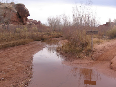
It is about 2.2 miles along this sandy 4WD road to the junction with Horse Canyon on the left. The Salt Creek route continues on the right to Peekaboo Springs and the not to be missed pictograph.

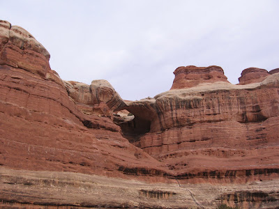
I thought this arch was Paul Bunyan's Potty but it actually belongs to someone smaller and doesn't seem to have a name. Paul apparently has a two holer. It took me about 1:15 hours to get to this point. The canyon floor here is fairly dense with vegetation and there appears to be a project of reducing the invasive Tamarisk trees.

It is possible to get off the trail and down into the wash for a closer look. This area has a lot of alcoves and cave formations that look like possible ruins sites. The ruins sites in this area mostly appear to be small storage sites.

About 15 minutes past the first arch there is a small storage ruin right at eye level along the sandy trail. These sites usually seem to be placed higher and are more hidden than this one.

The interpretive information at the Roadside Ruins site indicates that this region may have been used seasonally for farming but not so much for year round habitation.

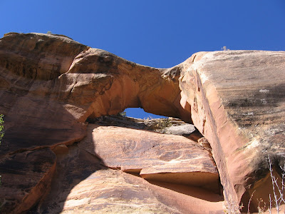
The Paul Bunyan Potty arch is looming just above the small storage ruin only a minute further away. There is a sign making the identification clear. Hiking past the Paul Bunyan arch toward Tower Ruin, both of the arches can be viewed at the same time.

There is a short side trail from the small loop parking area to get up under and get the clear sky view through the arch. It took me about 1:30 hours to get here hiking. This is a somewhat tiring route due to the sand.

I was always searching for a firmer surface to walk on. From the Paul Bunyan arch it is about 40 minutes further to get to Tower Ruin. My total hike was 4:10 hours for this 8 or 9 mile round trip.


Thursday, November 27, 2008

Tower Ruin Trail in Horse Canyon

The Tower Ruin Trail is a side route to a small ruins site off of the Horse Canyon trail in the Needles District of Canyonlands National Park in southeast Utah. It took me about 2:00 hours of hiking up Salt Creek and Horse Canyon to get to the side trail.

The trail junction is about 1.0 miles past the Paul Bunyan Potty arch and is marked with a small sign. The Horse Canyon Trail continues for several more miles to the south. It is about 0.7 miles more to arrive at the ruins site.


The Tower Ruin overlooks a broad grassy area surrounded by steep sandstone walls. This area looks somewhat like nearby Chesler Park but without the Needles. The trail to the ruins site was a little more firm and a relief after the sand of Horse Canyon.

The Tower Ruin is a small site but is in a towering position. It appears to be a storage site but someone may have lived there also.


The ruins site appears to be a tricky place to get up to and doesn't have much room, but it appears to be well preserved with some roof beams still in place.

On the return hike, further to the south, a large arch is visible about a mile away. The park map shows Gothic Arch to be in that area. It took me 2:30 hours to hike to Tower Ruins with stops at the Paul Bunyan arch and the smaller arch before it. The return hike took 1:40 hours for a total hike of 4:10 hours for this 8 or 9 mile round trip.


  528614_Cool Camo Russell Outdoors

Wednesday, November 26, 2008

Shay Canyon Petroglyph Trail

The Shay Canyon Petroglyph Trail is 1.9 miles past the well know Newspaper Rock Petroglyphs site on the way to the Needles District of Canyonlands National Park in southeast Utah.

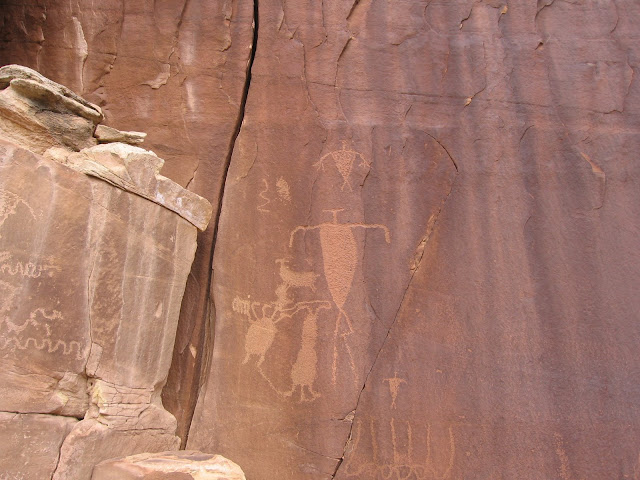
There is a pull over parking place on the west side of the road but there is not a sign. A trail leads down to Indian Creek and you have to find a place to step across the creek and then follow the trail to the right side of the canyon wall. Creek junctions like this one are a typical place to look for petroglyphs.

The Indian Creek has year round water and a lush riparian habitat between steep sandstone canyon walls. A little further west the canyon widens and there are good pasture and farm areas. The Shay Canyon Creek was dry in late fall when I visited.

These panels show a lot of animal figures mixed with some human figures. One can guess that there may be some relation to hunting rituals and to religious activity. There is no interpretation information at the site and we are left to admire the rock art and wonder about them.

Some of these figures are considered to be the Fremont Indian style but the Fremonts are not thought to have lived in this area. The style could have been copied by Ancestral Pueblos or perhaps the Fremonts visited this area for hunting. This view has the often noted copulating sheep in the upper left and a flute player in the lower left.

Most of the figures here are at eye level but there are a few that are very high on the sandstone walls in locations where it is hard to see how anyone got up there to work.

The cliffs in the Indian Creek corridor are Wingate Sandstone. This layer is below the Navajo and Entrada Sandstone layers that are seen near Arches National Park and above the Cedar Mesa Sandstone that forms the Needles.


Sunday, October 12, 2008

Peekaboo Springs Trail

The Peekaboo Springs Trail is a 5.0 mile route from the Squaw Flat Campground Trailhead east and south to Peekaboo Springs in the Needles District of Canyonlands National Park in southeast Utah.

It is part of an extensive network of trails that passes up and down on the carved rocks of this part of Canyonlands, giving long views from up above and passing through the desert environment and sometimes riparian areas down below.


There are three well marked trail junctions along the way. After the trail junction with Lost Canyon, about halfway through the hike, the rest of the way seemed like a high wire act, passing along fairly narrow ledges along the rims of several canyons in a row.


The trail passes through a small arch window in the massive rock at one point. 

There was one spot with about one mile to go that I thought was particularly treacherous. A very narrow and slanted ledge over a very severe drop off was scary enough that I didn't want to go that way again. Looking back at the spot it is hard to see any trail over there, but everyone seems to get past it.

This was a spot that I think needs a bar or something to hold on to. Otherwise, the route was easy to follow but had the typical difficulty that Canyonlands offers.

There are two ladders on the trail, the second one is right at the descent into the Peekaboo Springs area. It is situated in a narrow crack and is about 20 feet high. A thrilling finish to this somewhat dizzying hike.

You want to finish this hike if you can. There is a large pictograph panel at the very end. In addition to the two turtle shell like paintings, that are probably shields, there are some very faded red images in the same place that are much older and quite a few hand prints, not to mention a small arch.


It took me 2:15 hours to cover this 5.0 mile route. I hiked out on the Salt Creek 4WD road, about 2.5 miles back to Cave Springs, the main part of the park, relieved that I can tell the story.

Salt Creek Trail to Peekaboo Springs

The Salt Creek Trail is a 4WD and hiking route along a creek bed that can be accessed near the Cave Springs Trail in the Needles District of Canyonlands National Park in southeast Utah. A reasonable 2.5 mile or so hike is between Cave Springs and the rock art pictograph at Peekaboo Springs.

This route has a lot of water in the spring but is reasonably dry in the fall. I hiked in October from Peekaboo Springs back out to the Cave Springs area after starting from the Squaw Flat Campground trailhead and hiking the 5.0 miles to the Peekaboo pictograph panel.

Even in the fall there was some water in the area of Peekaboo Springs. This area is thought to have been inhabited by the farming Ancestral Pueblo people until about 1300 AD. The creek bottom area is very thick with brush and it is hard to stray off the trail.

Along the route there is a 4WD road junction into Horse Canyon leading to Paul Bunyan's Potty and Tower Ruins. Near this junction there are two cave formations on the west side of the route that appeared from a distance to be possible small ruins sites.

There are also several small formations that appear to be arches. In some cases these might just be notches but there are at several definite small arches.

Don't miss the rock art panel at Peekaboo Springs. Besides these turtle shell looking drawings, there are hand prints and a small arch by this ancient art work.


 I took about 2:00 hours to walk this route one way. Most of the way the walking is a little slow due to loose sand.


Saturday, October 11, 2008

Roadside Ruin Trail

The Roadside Ruin Trail is a short 0.3 mile loop trail is a small granary ruin in the Needles District of Canyonlands National Park in southeast Utah.

The trailhead is just a little past the visitor center and is one of the first attractions a first time visitor would come across. In addition to the small ruin, this is also a botany trail, identifying nine of the common plants in this desert environment.

Visible along the trail are the Pinon Pine and Utah Juniper trees, along with Prickly Pear Cactus, Big Sagebrush and Four-wing saltbush. Two grains mentioned are Indian Ricegrass and Peppergrass.
The ruin is tucked up under a small rock alcove. The interpretive information says that granaries were common in this area but there are few dwellings, indicating that farming was carried on here but the area was occupied only seasonally.
Granaries like this were used as storage for corn, seeds, and nuts. Canyonlands is mostly a geological hiking park, but there is a cultural overlay of ruins and rock art that adds interest to this carved rocky landscape. There is a similar granery near the Paul Bunyan Arch in Horse Canyon.


544544_$20 off any hotel booking of $350 or more with code TLSALE20

Friday, October 10, 2008

Indio Arch Trail

Indio Arch is along Utah Scenic Route 211 on the way to the Needles District of Canyonlands National Park in southeast Utah. There is not a sign pointing it out, but it is only 0.7 miles past the Newspaper Rock Historic Site.
 

To see the arch well you have to pass through some old campsites and find a path down to Indian Creek, step across the creek and climb the bank on the opposite side.


Climbing up the bank out of the creek bed, it looks like there is an old 4WD road under the cliffs. From the old road you can get up under the arch to see blue sky through it. In the fall there isn't much water in the creek, but there could be quite a bit of flow in the spring.

The Indian Creek flows out of the Blue Mountains to the south and creates a lush corridor in an other wise dry area. The cliffs along Indian Creek are popular with climbers and give a taste of the rocky world of Canyonlands.

The road to the old campsites is blocked, probably due to flash floods that occurred a few years ago. There is enough room to pull over and park along the highway. Information on finding this arch and others south of Moab, Utah can be found in the small guide book Natural Arches of the Moab Area (South) by Chris Moore.

Wednesday, September 24, 2008

Anticline Overlook Trail

The Anticline Overlook Trail is a short loop at the extreme north end of Canyon Rims Recreation Area in southeast Utah.
 The first view area is about 150 yards up the trail. This view area is to the east of the Island in the Sky District of Canyonlands National Park and Dead Horse Point State Park.

The view to the north finds the Colorado River winding through an area where the layers of rock have been bulged upwards, the curving layers obvious. From here there are also views of the potash mining ponds, large blue lagoons sitting among the red rocks.

Following the rocky loop trail clockwise, the view shifts from the Colorado River canyon to the Kane Creek Canyon. There is a rough looking road down below that crosses the Hurrah Pass from Kane Creek to the Colorado River side. The road isn't as rough as it looks from here. It is possible to easily drive and hike there.

In the extreme distance an arch is visible. My guess is that it is the South Window in Arches National Park.

Following around and looking southeast the La Sal Mountains loom over more of the Kane Creek Canyon. The overlook trails here are well equipped with guard fences and numerous benches to enjoy the overwhelming views.


528614_Cool Camo Russell Outdoors

Monday, September 22, 2008

Minor Overlook Trail in Canyon Rims


The Miner Overlook is a short gravel loop around a large rock outcrop and provides vews of the Colorado River in Canyon Rims Recreation area in southeast Utah. It is named for Park Service Worker David Minor who worked for many years in this area.

This view point looks to the west towards Dead Horse Point State Park and the Island in the Sky District of Canyonlands National Park. The views of the Colorado are as good or better than from those two more famous viewpoints.
To the northwest there is a view of the Potash Mining activity. Colorado River water is pumped into the salt bed underlying the rock formations here, then returned to the surface and evaporated, leaving the raw product.

The train tracks that carry the material to market are visible near Arches National Park and along Potash Road near Moab.
Most of the attention here is directed west toward the Canyonlands area but there also good views to the east of the nearby LaSal Mountains.

Sunday, September 21, 2008

Wineglass Arch Trail

The Wineglass Arch is a short distance off the main road, close to the Anticline Overlook at the north end of Canyon Rims Recreation Area in southeast Utah. It is one of about 50 reasonably large arches south of Moab and outside of Arches National Park.

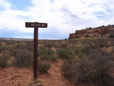
The Wineglass Arch is visible from the road. There are some trail segments, but it is easy just to cross the open field to the base of the rock outcrop. If you spend enough time in this area, I think you become more interested in becoming an arch spotter, taking time to see these small but otherwise rare formations.
Glancing up as I made my way toward Wineglass, there is a second arch about 100 feet to the north. Not a famous arch, but it appears to meet the three foot opening standard and qualifies.

Since there were two arches here, I continued around the backside of the formation looking for more, but I didn't see any.