Tuesday, December 22, 2009

Three Long Needles Day Hikes

The Needles District of Canyonlands National Park in southeast Utah is remote but a spectacular hiker park. There are many different trails and routes to follow, but if you want a long day hike that is representative, there are a few choices.

The trail to the heart of the Needles is the Chesler Park Trail. Start at the Elephant Hill Trail Head that is along a side road near the Squaw Flat Campground. The trail heads south with mostly easy walking toward Chesler Park, a wide open area surrounded by the sculpted Needles.

This area has a network of trails and there are several options, including Druid Arch and Devils Kitchen. The Elephant Hill 4WD road also heads for the heart of the Needles and can be used to make a loop route. It is about a 6 mile round trip to Chesler Park and back. Druid Arch is an 11 mile round trip. The Needles formations are the Cedar Mesa sandstone layer, a deeper layer than the Entrada sandstone that features the arches found in Arches NP.

The Canyonlands Park is divided into three districts by the Colorado and Green Rivers. These two famous western rivers flow together in the middle of the park. The Confluence Trail, at the west end of the district leads 5.5 miles to an overlook of the confluence, a view from 1000 feet above the rivers.

This trail starts off descending into a canyon then climbing out and uses some of the distant 4WD roads towards the end of the trail. The two rivers usually are different in color and the flow of each can be clearly viewed.


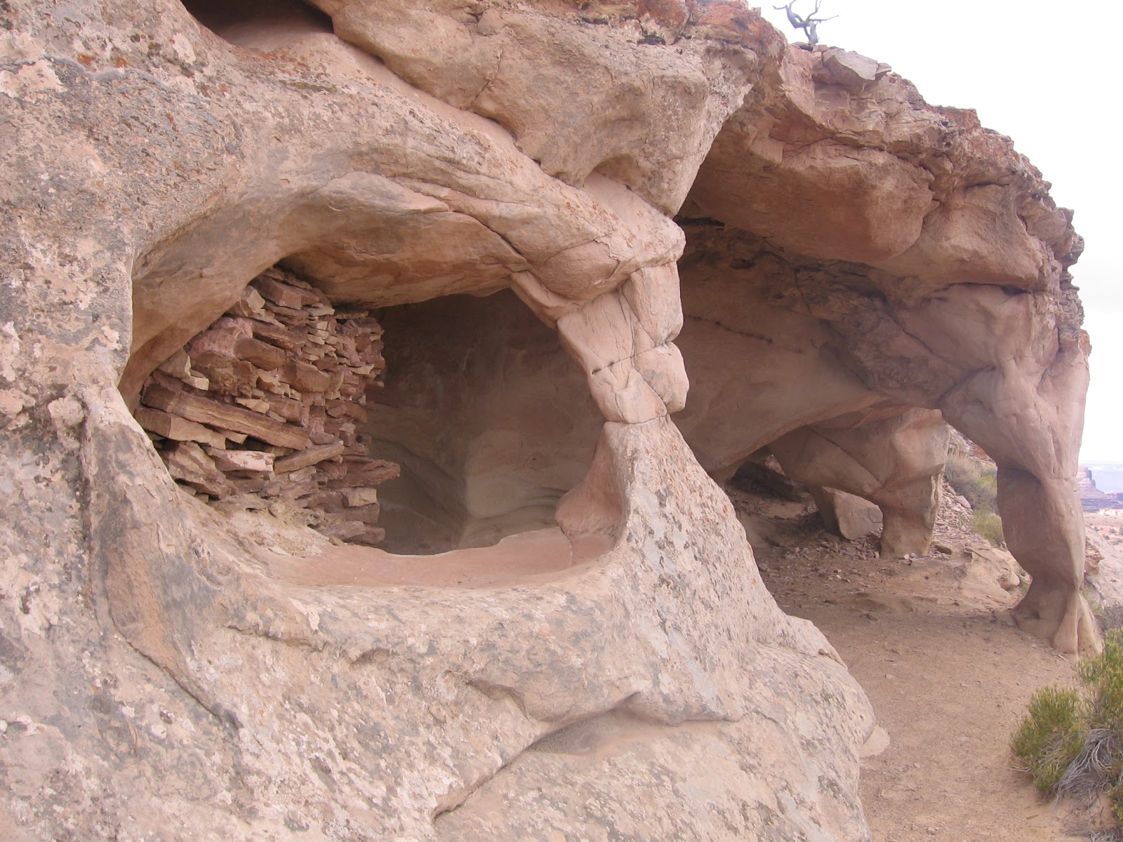
On the east side of the Needles District, the Salt Creek and Horse Canyon area has enough water to have supported the people who lived here before the arrival of pioneers. The Salt Creek Trail leads toward Peekaboo Springs and an excellent example of the rock art that can be found in the area.

 The hike to Peekaboo is a good destination, and further up Horse Canyon is the Paul Bunyan arch and the Tower Ruins site. Peekaboo Springs is a 5.4 mile round trip. Hiking all the way to Tower Ruin, past the Paul Bunyan Arch is a 9.6 mile round trip. Be sure to carry plenty of water on any of these hikes.

Tuesday, November 10, 2009

Hidden Rock Art

The Needles District of Canyonlands National Park in southeast Utah has a number of Rock Art Panels hidden in the canyons. Some of them are near trails and are well known, but sometimes in remote and hard to get to locations.

There are probably many others that are less known and not along any well traveled routes. This one is very good and not along a well traveled route. There are two side by side panels in an east facing alcove. The panel to the right has a gallery of reddish broad shouldered figures. The alcove is near a tamarisk filled creek in some white sandstone outcrops.
There are many white hand prints in the overall work also, some covering the reddish figures. The alcove overlooks a level area where mostly sagebrush is growing.

The panel to the left is mostly hand prints, some red and some white, and some direct prints and some outlines. This hidden panel is about 1 mile north of the Needles Visitor Center.


Lockhart Basin Trail to Pelican Arch

The road to Lockhart Basin and Hurrah Pass starts about two miles east of the park entrance to the Needles District of Canyonlands National Park in southeast Utah. The first 2.9 miles is easily drivable and passes the Hamburger Rock camping area toward a crossing of Indian Creek.

I started my hike right at the Indian Creek Crossing 2.9 miles down the road. Right at that point is the Indian Creek Falls, about a 20 foot drop off. In early November the Indian Creek was dry except for a brown pool at the base of the falls.

In spring, the crossing could be more than a foot deep. I didn’t get to see any flowing water, but my feet didn’t get wet hiking across. The road swings to the right after the crossing, then turns left and climbs away from the creek. A hiker can take a shortcut and climb directly up a sandy hill toward some arch looking rock formations and get back on the road.

The road follows along the creek for a while, then turns away and continues north toward the base of the Needles Overlook point. The top of the Needles Overlook is one of the short hiking attractions of the Canyon Rims Recreation Area that can be accessed off of Highway 191 north of the Highway 211 turnoff that leads to the Needles District of Canyonlands.

From that lofty viewpoint, the Lockhart Basin Road looks like a harsh and desolate area except for the green band of Indian Creek. A sign near the beginning of the road says it is 48 miles to Hurrah Pass. After Hurrah Pass, I think this road becomes Kane Creek Road and leads into Moab, connecting with Highway 191. During my hike I didn’t see any vehicles traveling along the road. There were several campers staying in the sites near Hamburger Rock.

About 2.5 miles down the trail there is a marked turnoff leading west down a small canyon drainage. The turnoff is labeled 25 by the Canyon Riders and is marked as being more difficult for drivers. About 0.5 miles down this side trail the Pelican Arch appears on the right.

Pelican Arch isn’t very large, barely big enough to crawl through. The Needles Overlook Point can be framed through the opening. The terrain in this area has a few scattered Utah Juniper Trees, Rabbitbrush, Mormon Tea and a few other desert shrubs. In a couple of spots the carved Needles formations can be sighted to the west.

Back at the Indian Creek Falls area, there is a pictograph panel a few hundred yards upstream that has white hand prints and lines of dots. A short distance to the right of the pictographs there are some faint petroglyphs.

My hike to the Pelican Arch took 3:00 hours for about 6 miles. It was a 60 F degree early November blue sky day and I drank 2 liters of water. I spent another 0:45 minutes looking upstream along Indian Creek for Rock Art and found just the two panels near the falls.


Tuesday, October 13, 2009

Chesler Park Trail to Devils Lane

The Chesler Park Trail is one of the most popular trails in the Needles District of Canyonlands National Park in southeast Utah. It leads to the extensive network of Needles Trails, in the seemingly impenetrable area of towering carved sandstone formations.

There are several options for hiking to Devils Lane and the other parallel narrow valleys that are referred to as The Grabens. I started my hike at the Elephant Hill Trail Head and hiked the popular route for 2.7 miles, and turned right onto the northern segment of the Devils Kitchen-Chesler Park Loop. This segment continues for 2.3 miles to the Devils Kitchen backcountry campground area. The Devils Kitchen area is at the east end The Grabens. It took me 2:45 hours to arrive here, about 5 miles of hiking.

Devils Kitchen can also be directly hiked to along the Elephant Hill 4WD loop road. The tall wall formations near the beginning of the Chesler Park Trail reminded me of the Courthouse Towers in Arches National Park.
The Needles area is always amazing to hike through. This layer of sandstone is the Cedar Mesa layer, a relatively deep layer on the Colorado Plateau. It is well below the Wingate, Navajo and Entrada layers that appear in Arches National Park and other areas of the Canyonlands area.

The vegetation in this area is dominated by Pinon Pines and Utah Junipers with small shrubs. There are small Gambel Oaks in a few places. The black crusty cryptobiotic soil is common along the trail.

From Devils Kitchen, it is 0.5 miles west to the 4WD road that runs in Devils Lane. The Devils Lane is a mostly level narrow valley between high rock walls and is a startling contrast from the jumbled and eroded area that surrounds it. The National Park Service has a web site that explains the formation of Devils Lane and the other Grabens.

The plastic nature of the salt layer underlying the sandstone seems to be the key factor. The Grabens are thought to be sliding toward the Colorado River at a very slow rate. The hiking along the road can be tiring as the footing is very sandy. Despite the deposited soil, the vegetation is very sparse compared to the rocky canyon areas nearby.

About 1.0 miles south along Devils Lane, there is a pictograph panel on the right. The panel is mostly red hand prints with two notable foot prints. The rock art panel is protected under a small overhang. It is about a 3.0 mile round trip from Devils Kitchen to the pictograph panel. This was about a 1:15 hour side trip.

This panel seemed to be isolated. There are no obvious ruins sites nearby. The Canyonlands area seems to be rich in rock art sites but doesn’t show many habitation sites. There are some small granary storage sites in a few places.

From the pictograph panel I returned the 1.5 miles back to the Devils Kitchen area and then followed the Elephant Hill 4WD road 3.5 miles back to the Trail Head. Near the junction of the 4WD road and Devils Kitchen, there is a small black hand print pictograph. My total hike was 11.5 miles in 5:30 hours. I carried 3 liters of water on a 65 F degree day in mid October.

544544_$20 off any hotel booking of $350 or more with code TLSALE20

Wednesday, September 23, 2009

Upheaval Dome Overlook Trail

The Upheaval Dome Overlook Trail leads to two view points of this unusual circular geologic feature. The round trip to the most distant view point is 1.6 miles. The trail head is at the end of the west leading road in the Island of the Sky District of Canyonlands NP is southeast Utah.

There are two theories attempting to explain Upheaval Dome. The more traditional explanation is that the salt layer below the accumulated sediment pushed upwards. The more recent proposal is that a meteor strike 60 million years ago caused the ¾ mile deep crater.
The trail has many steps carved into the rock to make the walk easier. Even with the relatively easy footing there are some ups and downs over the mostly bare sandstone that will make you stop to catch your breath. Most of the attention is directed toward the crater, but there are also scenic views on all sides. There is the 8.3 mile Syncline Valley Loop Trail that circles the Upheaval Dome and starts at the same point as the Upheaval Dome Overlook Trail.

The trail head area has a picnic area and was very busy on the day I visited. Most visitors stop at the first view point after 0.3 miles. I spent 1:10 hours on the 1.6 mile round trip on a mostly cloudy mid September day. I drank a full liter of water at the end of the hike.

Monday, September 21, 2009

Whale Rock Trail

The Whale Rock Trail is a 1.0 mile round trip to the top of a large sandstone outcrop in the Island of the Sky District of Canyonlands NP in southeast Utah.


The trail head is near the west end of the road leading toward the Upheaval Dome area. The trail head interpretive information emphasizes the adaptations the Pinon Pine and Utah Juniper forest plant community makes to survive in an area with only 9 inches of rain per year. The climb up on top is easy, though it looked like some railings that used to be in place have been removed.
From above it looks like the Whale Rock is actually at the head of a pod of whales circling around the outer edge of the Upheaval Dome. This short hike takes about 30 minutes,

Thursday, September 17, 2009

Aztec Butte Trail

The Aztec Butte Trail is a 1.5 mile round trip to several Ancestral Pueblo granary sites in the Island of the Sky District of Canyonlands National Park in southeast Utah. The trail head is along the paved road that leads west toward the Upheaval Dome area.


The trail follows a sandy route that circles around the small butte that is in front of Aztec Butte. There is a spur trail that climbs the back side to a pair of granary sites just under the rim. I climbed the spur trail first before going on to Aztec Butte. The Canyonlands area doesn’t seem to have any large village sites but has a number of small storage sites and rock art sites.
Further on, Aztec Butte is about a 200 foot climb to the top with the granary sites under the rim on the north side. The butte is one of the highest view points in the immediate area. There are a couple of steep spots climbing up the sandstone face of the Butte that call for a little scrambling. I had a little trouble finding the right spots to put my feet at the point just below the rim but made it up.

On top there is a circular trail that I followed clockwise. There are several small sites along the somewhat narrow ledge overlooking the very deep Trail Canyon.


The alcoves seem to feature a number of small arch formations that act as support columns and entryways. There are four or five sections of ancient walls along the length of the ledge.

There is also a circular structure on the top of the mesa. The Mesa Arch Trail area is visible only a short distance to the east. Also in this area of the park is the Green River Overlook. There isn’t a trail there but there is a glimpse of the Green River and the formations known as Cleopatra’s Chair and the Turk’s Head and others.

There is also some discussion of John Wesley Powell’s expedition of exploration down the Green and Colorado River. He passed by the area of the overlook on July 16, 1869. My hike at Aztec Butte took about 1:15 hours for the 1.5 miles.


Wednesday, September 16, 2009

Grand View Point Trail

The Grand View Point Trail is a 2.0 mile round trip along the rim at the south end of the Island in the Sky District of Canyonlands NP in southeast Utah. From this trail are some of the most spectacular views of Canyonlands.

The three fingered area just below the trail head area is Monument Basin, featuring some tall spires. At the junction of the fingers is the tallest of the monuments, the Totem Pole. The White Rim Road can be seen snaking around the edges of the basin. This road is a favorite with mountain bikers for its endless scenery. The White Rim is about 1000 feet below this view point. The trail travels southwest from the main view point.
The views to the west are towards the confluence of the Green River and the Colorado River. According to the interpretive information, the Colorado River above the confluence was known as the Grand River until 1921, hence the name Grand View Point. The Colorado/Grand River has cut so deeply into the rocks that it is not visible here. In the Needles District of Canyonlands the 5.5 mile Confluence Overlook Trail leads to the point above where the two streams flow together.

At the end of the trail there are views back to the northwest with a glimpse of the Green River. The Green starts in the Wind River Mountain Range in Wyoming. There is a Green River Overlook Point near the Aztec Butte Trail about 6 miles north of this point where some of the same terrain can be viewed from a different angle. My hike on the Grand View Overlook Trail took about 1:00 hour for the 2 miles.

White Rim Overlook Trail

The White Rim Overlook Trail is a 2 mile round trip across high desert Pinon and Juniper terrain to a rocky cliff giving a view to the south and east, with glimpses of the Colorado River.

The trail head is at the Gooseberry Picnic Area is toward the south end of the main road in Island in the Sky District of Canyonlands NP in southeast Utah. The Gooseberry Picnic Area has two trail choices. The longer Gooseberry Trail leads to the north and down to the White Rim Road. Some of the formations that are visible from the Mesa Arch Trail are also visible here.

At the end of the trail are some views similar to the Monument Basin View on the nearby Grand View Point Trail. These views are slightly to the east of the Grand View Point. This 2 mile hike took me about 1:00 hour.

Tuesday, September 15, 2009

Mesa Arch Trail

The Mesa Arch Trail is a 0.5 mile loop trail to a scenic arch and canyon overlook in the Island in the Sky District of Utah’s Canyonlands National Park.

The trail head is a few miles south of the entrance gate and the Visitor Center on the main park road. The trail has many constructed steps for easy walking and passes through a sandy area of Pinon Pine and Utah Juniper to the arch perched on the rim of Buck Canyon. The canyon floor is 1200 feet below.
On a clear day the LaSal Mountains to the east can be framed through the arch. Along the left there is also a distant view of Washerwoman Arch.

It is possible to view Washerwoman Arch through Mesa Arch. This arch is a favorite of photographers who arrive at dawn to catch the rosy glow as it highlights the bottom edges of the arch. This short hike takes about 30 minutes.

544544_$20 off any hotel booking of $350 or more with code TLSALE20

Thursday, June 18, 2009

Aqueduct Arch Trail

The Aqueduct Arch Trail starts about 11.2 miles north along Harts Point Road in the Canyon Rims Recreation Area in southeast Utah and is not marked. The Harts Point area is between Canyonlands Park and Indian Creek to the west and the Hatch Point district of Canyon Rims to the east.

The Harts Point Road is about 12 miles west along Utah Route 211 on the way to the Needles District of Canyonlands Park. This area is wild and remote canyon country with no facilities for visitors.

There is a two track 4WD road leading east off of the graded road for about 2.2 miles from the unmarked trail head, then a right turn that leads for a short distance and the road ends. The walking along the slightly sandy road is easy and there are good canyon views to the east toward the La Sal Mountains.

The end of the road overlooks a side canyon of Harts Draw. The arch is near the bottom of the main part of this side canyon, and is not visible from the end of the road.

There are some hiker cairns leading down through a cliff area and then the route follows a small drainage to the canyon rim. The arch is visible toward the east side. There are more rock cairns leading down from the rim into a side canyon that allow a closer view. I went down to the next main shelf below the rim and stopped there.

The route continues further down into the canyon but appears to get more difficult. Aqueduct Arch looks like it was once a large deep alcove and the roof collapsed. There are other similar alcoves that are visible in the area. I scanned with binoculars for Ancestral Pueblo ruins in the alcoves but didn’t spot anything.

It took me about 0:45 minutes to get to the end of the 4WD road and I hiked another 30 minutes to the rim and somewhat down into the canyon. It was a relatively cool 70 F mid June day and I carried two liters of water. My total hike was 2:40 hours. Nearby to the Aqueduct Arch route is a shorter hike to Mug Handle Arch. The Chris Moore Guide to Natural Arches in the Moab Area is very helpful for finding these large spectacular arches.

Wednesday, June 17, 2009

Mug Handle Arch Trail

The Mug Handle Arch Trail is in the Harts Point section of the Canyon Rims Recreation Area in southeast Utah. The Harts Point Area is a mesa top that overlooks the east side of the Indian Creek corridor that leads to the Needles District of Canyonlands National Park.

About 12 miles along Utah scenic route 211 there is a sign pointing out Harts Draw Road to the south. The road to Harts Point is the north leading part of the same road. The Harts Point area doesn't have any visitor facilities. I started my hike 11.6 miles along this graded road next to an old windmill on the west side. The turbine for the windmill is in ruins on the ground and has been there so long a sage brush is growing up though it.

The unmarked trail to Aqueduct Arch begins in this same vicinity. The terrain here is scattered Pinon Pines and Utah Junipers with areas where sage brush dominates. There is good canyon country in the Harts Point area, but not the spectacular view points that are the highlight of the more developed Hatch Point area of Canyon Rims.

From the old windmill I walked about 5 minutes west along the two track road to a point where there were some views down into one of the canyons that is along the Indian Creek area, then worked back south and east along the side canyon rim, crossing a large area of slick rock sandstone. The road I walked on is more or less parallel to the canyon with the arch.

The Mug Handle Arch is back toward the head of the canyon and is not visible immediately. There is a shelf below the canyon rim that allows a reasonable approach for a good view. There isn't a trail so a hiker has to pick his own route. There are a number of large alcoves in this side canyon that look like good potential Ancestral Pueblo ruins sites but I didn't see any standing structures.

It is easy to view the Mug Handle Arch from the opposite side and a shorter walk. From the old windmill, the canyon head is only a few hundred yards directly south. From the canyon head there are good views down canyon toward what looks like the Dugout Ranch area of Indian Creek. The huge Wingate Sandstone cliffs visible below are popular climbing areas.

I spent about 1:30 hiking in the Mug Handle Arch area. The distance was less than 1 mile with much of the time spent scanning and moving slowly over the uneven terrain. Chris Moore’s guide book to the Natural Arches of the Moab Area is very helpful in finding these large unmarked arches.

Friday, March 20, 2009

Elephant Hill Trail to Devils Kitchen

The Elephant Hill 4WD Trail includes a 9.3 mile loop route past Devils Kitchen in the Needles District of Canyonlands National Park in southeast Utah.
  The Trail Head at Elephant Hill is also the starting point for popular hikes to Chesler Park and Druid Arch. The 4WD trail is rough for vehicles but the walking is reasonably easy, similar to the hiking trails but wider.

There is a 1.5 mile segment before arriving at the loop portion. I followed the loop clockwise, going the same way that vehicles go. The first part of the hike climbs steeply over rock and then follows a two track sandy road.

Some of the rocky portions look like some concrete has been used to fill in the bumpiest parts. There are some small signs advising drivers where to back down sections that are too narrow for a normal turn. In the first half of the loop there is a hand print pictograph visible.

The Devil's Kitchen area is a backpacker campground centered around some rock formations that are particularly black with desert varnish, giving the appearance of having been scorched by sooty fires. There are some short trails into these formations that are shady and cool.

North and south from the Devils Kitchen is Devils Lane, a narrow grassy corridor with some of the bordering rock formations also blackened by desert varnish. The south section approaches the famous Needles formations. (There is some rock art about 1 mile down the Lane.)

One section is named the Silver Stairs, a rocky stair step descent down from the Devils Lane. This section is easy to hike over but would be bumpy for a vehicle.

The last portion of the loop had a number of small arches to spot. It took me about 4:00 hours to cover this 9.3 mile route. I carried three liters of water on a 65 F. degree day. I only saw one Jeep on the trail on a week day in mid March.


18407_$5 Shipping on Orders of $99 or More!