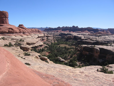
 It is part of an extensive network of trails that passes up and down on the carved rocks of this part of Canyonlands, giving long views from up above and passing through the desert environment and sometimes riparian areas down below.

There are three well marked trail junctions along the way. After the trail junction with Lost Canyon, about halfway through the hike, the rest of the way seemed like a high wire act, passing along fairly narrow ledges along the rims of several canyons in a row.

The trail passes through a small arch window in the massive rock at one point.
 There was one spot with about one mile to go that I thought was particularly treacherous. A very narrow and slanted ledge over a very severe drop off was scary enough that I didn't want to go that way again. Looking back at the spot it is hard to see any trail over there, but everyone seems to get past it.
This was a spot that I think needs a bar or something to hold on to. Otherwise, the route was easy to follow but had the typical difficulty that Canyonlands offers.
 There are two ladders on the trail, the second one is right at the descent into the Peekaboo Springs area. It is situated in a narrow crack and is about 20 feet high. A thrilling finish to this somewhat dizzying hike.
 You want to finish this hike if you can. There is a large pictograph panel at the very end. In addition to the two turtle shell like paintings, that are probably shields, there are some very faded red images in the same place that are much older and quite a few hand prints, not to mention a small arch.
It took me 2:15 hours to cover this 5.0 mile route. I hiked out on the Salt Creek 4WD road, about 2.5 miles back to Cave Springs, the main part of the park, relieved that I can tell the story.
 This route has a lot of water in the spring but is reasonably dry in the fall. I hiked in October from Peekaboo Springs back out to the Cave Springs area after starting from the Squaw Flat Campground trailhead and hiking the 5.0 miles to the Peekaboo pictograph panel.


 The trailhead is just a little past the visitor center and is one of the first attractions a first time visitor would come across. In addition to the small ruin, this is also a botany trail, identifying nine of the common plants in this desert environment.


