Showing posts with label Petroglyphs. Show all posts

Tuesday, November 10, 2009

Hidden Rock Art

The Needles District of Canyonlands National Park in southeast Utah has a number of Rock Art Panels hidden in the canyons. Some of them are near trails and are well known, but sometimes in remote and hard to get to locations.

There are probably many others that are less known and not along any well traveled routes. This one is very good and not along a well traveled route. There are two side by side panels in an east facing alcove. The panel to the right has a gallery of reddish broad shouldered figures. The alcove is near a tamarisk filled creek in some white sandstone outcrops.
There are many white hand prints in the overall work also, some covering the reddish figures. The alcove overlooks a level area where mostly sagebrush is growing.

The panel to the left is mostly hand prints, some red and some white, and some direct prints and some outlines. This hidden panel is about 1 mile north of the Needles Visitor Center.


Lockhart Basin Trail to Pelican Arch

The road to Lockhart Basin and Hurrah Pass starts about two miles east of the park entrance to the Needles District of Canyonlands National Park in southeast Utah. The first 2.9 miles is easily drivable and passes the Hamburger Rock camping area toward a crossing of Indian Creek.

I started my hike right at the Indian Creek Crossing 2.9 miles down the road. Right at that point is the Indian Creek Falls, about a 20 foot drop off. In early November the Indian Creek was dry except for a brown pool at the base of the falls.

In spring, the crossing could be more than a foot deep. I didn’t get to see any flowing water, but my feet didn’t get wet hiking across. The road swings to the right after the crossing, then turns left and climbs away from the creek. A hiker can take a shortcut and climb directly up a sandy hill toward some arch looking rock formations and get back on the road.

The road follows along the creek for a while, then turns away and continues north toward the base of the Needles Overlook point. The top of the Needles Overlook is one of the short hiking attractions of the Canyon Rims Recreation Area that can be accessed off of Highway 191 north of the Highway 211 turnoff that leads to the Needles District of Canyonlands.

From that lofty viewpoint, the Lockhart Basin Road looks like a harsh and desolate area except for the green band of Indian Creek. A sign near the beginning of the road says it is 48 miles to Hurrah Pass. After Hurrah Pass, I think this road becomes Kane Creek Road and leads into Moab, connecting with Highway 191. During my hike I didn’t see any vehicles traveling along the road. There were several campers staying in the sites near Hamburger Rock.

About 2.5 miles down the trail there is a marked turnoff leading west down a small canyon drainage. The turnoff is labeled 25 by the Canyon Riders and is marked as being more difficult for drivers. About 0.5 miles down this side trail the Pelican Arch appears on the right.

Pelican Arch isn’t very large, barely big enough to crawl through. The Needles Overlook Point can be framed through the opening. The terrain in this area has a few scattered Utah Juniper Trees, Rabbitbrush, Mormon Tea and a few other desert shrubs. In a couple of spots the carved Needles formations can be sighted to the west.

Back at the Indian Creek Falls area, there is a pictograph panel a few hundred yards upstream that has white hand prints and lines of dots. A short distance to the right of the pictographs there are some faint petroglyphs.

My hike to the Pelican Arch took 3:00 hours for about 6 miles. It was a 60 F degree early November blue sky day and I drank 2 liters of water. I spent another 0:45 minutes looking upstream along Indian Creek for Rock Art and found just the two panels near the falls.


Tuesday, October 13, 2009

Chesler Park Trail to Devils Lane

The Chesler Park Trail is one of the most popular trails in the Needles District of Canyonlands National Park in southeast Utah. It leads to the extensive network of Needles Trails, in the seemingly impenetrable area of towering carved sandstone formations.

There are several options for hiking to Devils Lane and the other parallel narrow valleys that are referred to as The Grabens. I started my hike at the Elephant Hill Trail Head and hiked the popular route for 2.7 miles, and turned right onto the northern segment of the Devils Kitchen-Chesler Park Loop. This segment continues for 2.3 miles to the Devils Kitchen backcountry campground area. The Devils Kitchen area is at the east end The Grabens. It took me 2:45 hours to arrive here, about 5 miles of hiking.

Devils Kitchen can also be directly hiked to along the Elephant Hill 4WD loop road. The tall wall formations near the beginning of the Chesler Park Trail reminded me of the Courthouse Towers in Arches National Park.
The Needles area is always amazing to hike through. This layer of sandstone is the Cedar Mesa layer, a relatively deep layer on the Colorado Plateau. It is well below the Wingate, Navajo and Entrada layers that appear in Arches National Park and other areas of the Canyonlands area.

The vegetation in this area is dominated by Pinon Pines and Utah Junipers with small shrubs. There are small Gambel Oaks in a few places. The black crusty cryptobiotic soil is common along the trail.

From Devils Kitchen, it is 0.5 miles west to the 4WD road that runs in Devils Lane. The Devils Lane is a mostly level narrow valley between high rock walls and is a startling contrast from the jumbled and eroded area that surrounds it. The National Park Service has a web site that explains the formation of Devils Lane and the other Grabens.

The plastic nature of the salt layer underlying the sandstone seems to be the key factor. The Grabens are thought to be sliding toward the Colorado River at a very slow rate. The hiking along the road can be tiring as the footing is very sandy. Despite the deposited soil, the vegetation is very sparse compared to the rocky canyon areas nearby.

About 1.0 miles south along Devils Lane, there is a pictograph panel on the right. The panel is mostly red hand prints with two notable foot prints. The rock art panel is protected under a small overhang. It is about a 3.0 mile round trip from Devils Kitchen to the pictograph panel. This was about a 1:15 hour side trip.

This panel seemed to be isolated. There are no obvious ruins sites nearby. The Canyonlands area seems to be rich in rock art sites but doesn’t show many habitation sites. There are some small granary storage sites in a few places.

From the pictograph panel I returned the 1.5 miles back to the Devils Kitchen area and then followed the Elephant Hill 4WD road 3.5 miles back to the Trail Head. Near the junction of the 4WD road and Devils Kitchen, there is a small black hand print pictograph. My total hike was 11.5 miles in 5:30 hours. I carried 3 liters of water on a 65 F degree day in mid October.

544544_$20 off any hotel booking of $350 or more with code TLSALE20

Wednesday, March 18, 2009

Indian Creek Petroglyph Trail


The Indian Creek Petroglyph Trail is a short climb up to a petroglyph panel in the lush Indian Creek corridor on the way to the Needles District of Canyonlands National Park in southeast Utah.
  The unmarked trail head is 2.7 miles past the well known Newspaper Rock site at Mile Post 4, on the east side of Utah Highway 211. The trail is only a few hundred yards long. The panel faces the highway and is at the base of the exposed Wingate Sandstone cliffs that line Indian Creek in this area.

This is a popular climbing area and there are at least three accessible petroglyph panels close together here. The Shay Canyon site is 1.9 miles past Newspaper Rock on the west side of Indian Creek.There is a main panel in the center with more figures to the left and also some to the right. The panel to the right is more eroded than the center panel. This rock art site features some very large figures.

A highlight of this panel is the archer in the lower left corner with huge feet. There seems to be some historic markings from 1911. The Mountain Sheep is the upper left are nicely done.

To the left are several large humanoid figures. There also seem to be a number of crescent moons in this panel, with one or two more near the sheep in the upper left.

532497_120 x 90 Starting Salary $42k. Group 1

Wednesday, November 26, 2008

Shay Canyon Petroglyph Trail

The Shay Canyon Petroglyph Trail is 1.9 miles past the well know Newspaper Rock Petroglyphs site on the way to the Needles District of Canyonlands National Park in southeast Utah.

There is a pull over parking place on the west side of the road but there is not a sign. A trail leads down to Indian Creek and you have to find a place to step across the creek and then follow the trail to the right side of the canyon wall. Creek junctions like this one are a typical place to look for petroglyphs.

The Indian Creek has year round water and a lush riparian habitat between steep sandstone canyon walls. A little further west the canyon widens and there are good pasture and farm areas. The Shay Canyon Creek was dry in late fall when I visited.

These panels show a lot of animal figures mixed with some human figures. One can guess that there may be some relation to hunting rituals and to religious activity. There is no interpretation information at the site and we are left to admire the rock art and wonder about them.

Some of these figures are considered to be the Fremont Indian style but the Fremonts are not thought to have lived in this area. The style could have been copied by Ancestral Pueblos or perhaps the Fremonts visited this area for hunting. This view has the often noted copulating sheep in the upper left and a flute player in the lower left.

Most of the figures here are at eye level but there are a few that are very high on the sandstone walls in locations where it is hard to see how anyone got up there to work.

The cliffs in the Indian Creek corridor are Wingate Sandstone. This layer is below the Navajo and Entrada Sandstone layers that are seen near Arches National Park and above the Cedar Mesa Sandstone that forms the Needles.


Sunday, October 12, 2008

Peekaboo Springs Trail

The Peekaboo Springs Trail is a 5.0 mile route from the Squaw Flat Campground Trailhead east and south to Peekaboo Springs in the Needles District of Canyonlands National Park in southeast Utah.

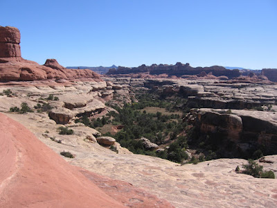
It is part of an extensive network of trails that passes up and down on the carved rocks of this part of Canyonlands, giving long views from up above and passing through the desert environment and sometimes riparian areas down below.


There are three well marked trail junctions along the way. After the trail junction with Lost Canyon, about halfway through the hike, the rest of the way seemed like a high wire act, passing along fairly narrow ledges along the rims of several canyons in a row.


The trail passes through a small arch window in the massive rock at one point. 

There was one spot with about one mile to go that I thought was particularly treacherous. A very narrow and slanted ledge over a very severe drop off was scary enough that I didn't want to go that way again. Looking back at the spot it is hard to see any trail over there, but everyone seems to get past it.

This was a spot that I think needs a bar or something to hold on to. Otherwise, the route was easy to follow but had the typical difficulty that Canyonlands offers.

There are two ladders on the trail, the second one is right at the descent into the Peekaboo Springs area. It is situated in a narrow crack and is about 20 feet high. A thrilling finish to this somewhat dizzying hike.

You want to finish this hike if you can. There is a large pictograph panel at the very end. In addition to the two turtle shell like paintings, that are probably shields, there are some very faded red images in the same place that are much older and quite a few hand prints, not to mention a small arch.


It took me 2:15 hours to cover this 5.0 mile route. I hiked out on the Salt Creek 4WD road, about 2.5 miles back to Cave Springs, the main part of the park, relieved that I can tell the story.

Friday, June 13, 2008

Newspaper Rock Petroglyphs

Newspaper Rock is an easily accessible Petroglyph Panel along Utah Highway 211 on the way to The Needles District of Canyonlands National Park in southeast Utah. It is a comfortable location and easy to view. The interpretive information at the site indicates that 2000 years of man's activities in the area are recorded here.


There are no methods of dating scratchings on the sandstone and there are no conclusions from scholars on what the drawings mean. I notice that there are several human figures with animal heads and many of the foot print drawings have six or more toes. The Navajo name for the site is "the rock that tells a story."


The 200 square foot rock panel is a part of the vertical Wingate sandstone cliffs that dominate the upper end of Indian Creek Canyon. This layer is below the Navajo and Entrada Sandstone layers that are seen near Arches National Park and above the Cedar Mesa Sandstone that forms the Needles in Canyonlands.


The setting for Newspaper Rock is along Indian Creek, a lush riparian habitat area fed by water flowing north from the Abajo Mountains. The area along the shady creek banks are thick with cottonwood trees.

In 2003 this area experienced a major flash flood, which washed out a section of Highway 211. This flood damaged the majority of campsites that are across the road, burying fire rings and damaging picnic tables. The campground has been closed for restoration and due to the possibility of more flash floods.

 In the vicinity of Newspaper Rock, there is also Indio Arch and the Shay Canyon Petroglyph site that are not pointed out with signs but are interesting to visit. Past Shay Canyon is another Indian Creek Petroglyph site.

528614_Cool Camo Russell Outdoors

Thursday, March 20, 2008

Cave Springs Trail

The Cave Springs Trail in the Needles District of Canyonlands National Park is a short 0.5 mile loop that features some of the human history of the area, along with the natural history.

The trail leads to some alcoves that were used as cowboy camps from the late 1800s until as recently as 1975, when grazing was discontinued inside the Park.

A collection of cowboy artifacts are on display, although you can't get up close to see them. The cowboys had a tough life, leading the herds over a large rugged area. The trail guide says that the Scorup-Sommerville Cattle Company had up to 10,000 head ranging over 1,800,000 acres.

The Cave Spring was the reliable water source for the cowboys, though it doesn't look like much. The water seeps down through the porous sandstone until it reaches an opening. Maidenhair fern adds a nice touch, growing along the alcove walls.

On the alcove wall above the Springs there are some pictographs indicating the past use of the same site by Ancestral Pueblo people. There are a few ruins sites in other parts of the park such as the Roadside Ruins and Tower Ruins and a small granery near Paul Bunyan's Arch.

After the cowboy alcoves, there are two ladders to climb to get up on the sandstone slickrock, where there are scenic views. Along the trail, the local plants are well marked.

The lower area of the trail has a lot of sagebrush, salt bush, and greasewood, plants that look similar from a distance. The slick rock area has Pinon Pine and Juniper trees. This is a botany trail also, with several of the native plants identified with signs.