 The trail to the heart of the Needles is the Chesler Park Trail. Start at the Elephant Hill Trail Head that is along a side road near the Squaw Flat Campground. The trail heads south with mostly easy walking toward Chesler Park, a wide open area surrounded by the sculpted Needles.
 This area has a network of trails and there are several options, including Druid Arch and Devils Kitchen. The Elephant Hill 4WD road also heads for the heart of the Needles and can be used to make a loop route. It is about a 6 mile round trip to Chesler Park and back. Druid Arch is an 11 mile round trip. The Needles formations are the Cedar Mesa sandstone layer, a deeper layer than the Entrada sandstone that features the arches found in Arches NP.
 The Canyonlands Park is divided into three districts by the Colorado and Green Rivers. These two famous western rivers flow together in the middle of the park. The Confluence Trail, at the west end of the district leads 5.5 miles to an overlook of the confluence, a view from 1000 feet above the rivers.
 This trail starts off descending into a canyon then climbing out and uses some of the distant 4WD roads towards the end of the trail. The two rivers usually are different in color and the flow of each can be clearly viewed.

On the east side of the Needles District, the Salt Creek and Horse Canyon area has enough water to have supported the people who lived here before the arrival of pioneers. The Salt Creek Trail leads toward Peekaboo Springs and an excellent example of the rock art that can be found in the area.
The hike to Peekaboo is a good destination, and further up Horse Canyon is the Paul Bunyan arch and the Tower Ruins site. Peekaboo Springs is a 5.4 mile round trip. Hiking all the way to Tower Ruin, past the Paul Bunyan Arch is a 9.6 mile round trip. Be sure to carry plenty of water on any of these hikes.


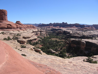 It is part of an extensive network of trails that passes up and down on the carved rocks of this part of Canyonlands, giving long views from up above and passing through the desert environment and sometimes riparian areas down below.


