Tuesday, November 6, 2012

Hunter Canyon to Kane Creek Canyon on Foot


The Hunter Canyon Trail and campground is located about 7.5 miles west along Kane Creek Road, west of Highway 191 in Moab in southeast Utah. The gravel road continues on for about 3.5 miles to a junction with the Kane Creek Trail and then another 3.0 miles to Hurrah Pass.


This route is a popular area for mountain biking and motorized but hikers can use the road also. The first segment meanders in a shady deep walled canyon along the bank of Kane Creek.


After about 1 mile the views open up. The canyon wall to the north is part of the view that is visible from the Anticline Overlook at the north end of the Canyon Rims Recreation Area. The rock layers have a slight curve to them. There isn't much vegetation here except for the riparian habitat in Kane Creek.


Toward the south the Anticline Overlook Point is visible to the west. With binoculars, the safety railings around the point are visible. The Hurrah Pass is directly north of and below the point.


In the fall of 2012, there are the new Ledge Campgrounds in this area. There are the Ledge A, B, and C and a Group site. These campgrounds replace the dispersed sites that were along Kane Creek. The new campgrounds improve the sanitary conditions for camping in this area. For hikers, this can be a place to sit and enjoy the views. 


Many of the replaced camping areas are now fenced off to allow the vegetation to recover. The Ledge B and C campgrounds are close to the junction with the Kane Creek Trail.


I turned around at the junction of the main road with the junction with the rougher Kane Creek Canyon Trail that goes to the left. Staying to the right on the main trail leads to the Hurrah Pass and Chicken Corners. Almost all vehicles can drive to this junction and start hikes here.


It took me 1:40 hours to arrive at the junction with the Kane Creek Canyon Trail. My return hike took 1:30 hours for a total hike of 3:40 hours for about 7 miles. I carried 3 liters of water on a 64 F degree early November day. 


Tuesday, October 23, 2012

Trough Springs Trail in Canyon Rims


The Trough Springs Trail is a 2.5 mile historic cattle trail in Canyon Rims Recreation Area, a large mesa top area to the east of Canyonlands National Park in southeast Utah. 

The Hatch Point District of Canyon Rims is about 32 miles south of Moab along Highway 191 in southeast Utah. The marked entry road is north of the Route 211 entry road to the Needles District of Canyonlands.


The trail head is at the end of a short dirt road in the north end of the Canyon Rims area, near the Anticline Overlook Trail. There are many dirt road opportunities and short overlook point trails for hiking in Canyon Rims but this appears to be the only actual hiking trail.


The trail descends 1100 feet to a junction with Kane Creek Canyon. The terrain here is scattered Pinon Pine and Utah Juniper trees, Single Leaf Ash, Black Brush, Cactus, and Mormon Tea along dry rocky washes. The trail is well marked with rock cairns.

The La Sal Mountains are visible to the east. The trail dates from the early 1900s and was used to move stock from the canyon rim to the Kane Creek Canyon below.


As the trail descends the massive Navajo and Wingate sandstone cliffs common in the region appear. The first segment of trail is a gradual descent with wide views.


After about 0:40 minutes and 1.3 miles the trail becomes more dramatic as it descends steeply into the Trough Springs Canyon. The route passes below the steep Wingate Sandstone and enters the rugged Chinle layer.


The trial crosses around the head of the canyon and descends mostly on the west side. This segment is similar to the trails in the Island of the Sky District of Canyonlands as you have to watch for the cairns and step carefully.  


It took me 0:40 minutes to descend along this steep segment, 1:20 hours total to arrive at the canyon floor. There was water flowing at the bottom and a thick growth of Cottonwoods and Willows.


Except for a few vague spots the walking toward Kane Creek Canyon was easy along a route that seemed like a cow trail. Since there was water here I kept an eye out for ruins sites and petroglyphs but didn't notice anything. The flowing water seems to be reabsorbed into the creek bed. I didn't see any flow toward the junction with Kane Creek.


didn't try to cross the wide eroded wash at the end of the trail. The 4WD trail along Kane Creek is visible here on the other side, and I saw two vehicles pass by. It took me about 2:00 hours to arrive at this junction.


My return hike took 2:25 hours for a total hike of 4:35 hours for 5 miles. The steep segment took me 1:00 hour to climb after taking 0:40 minutes to descend. I carried and drank 3 liters of water on a 65 F degree late October day. 


Wednesday, May 9, 2012

Horseshoe Canyon Trail-High Gallery and Horseshoe Shelter


The Horseshoe Canyon Trail is a 6.5 mile round trip with 750 feet of elevation change to four rock art sites including the Great Gallery. It is located in a detached Unit of Canyonlands National Park in southeast Utah.

 I traveled to Horseshoe Canyon by starting in Green River, Utah and following Utah Route 24 for 24 miles to the east leading gravel road turnoff that is across from the turnoff to Goblin Valley State Park.


It is then 32 miles on the gravel road to the trailhead. The road is drivable with 2-wheel drive but has many washboard sections and occasional sandy spots. After 27 miles there is a left turn at the junction with the road that leads south to the Hans Flat Ranger Station. This junction has some area information posted at a kiosk.

After 3.2 more miles there is an easy to miss right turn onto a one lane dirt road that leads the last 1.8 miles. At the trailhead, there is a pit toilet and an information kiosk. The kiosk information shows a map of the trail. It would be good to take notes on where the rock art sites are in relation to each other because they are not all completely obvious. There isn’t a printed trail guide for this spectacular trail.


The first segment of trail follows a rocky old road that was constructed for oil exploration. There are good views down the canyon that was formerly called Barrier Canyon. The creek seems to still be called Barrier Creek though the canyon has changed names.

A single three toed dinosaur track was outlined with small stones in the upper part of the trail. The last segment of the descent has sandy footing. Much of the canyon bottom has sandy footing also. It took me 0:30 minutes to arrive at the canyon bottom and the trail makes a right turn to the south.


The first rock art site, the High Gallery, arrived in 0:15 minutes more of hiking and was obvious on the left or east wall. The trailhead information says that Barrier Canyon rock art was created by Archaic hunter-gatherers in 1000-2000 BC. Most of the figures are colored red by the mineral hematite.


The canyon bottom is lush is spots with Cottonwood trees and other riparian habitat. There wasn't any flowing water during my hike, but there were wet spots and water is probably just below the surface.

The second rock art site, the Horseshoe Shelter, is within view of the High Gallery but is across the creek on the west side, somewhat concealed by the Cottonwood trees. There is a trail segment on the left side of the creek and it is easy to walk past the second rock art site without seeing the side trail on the right side.


There are two panels to find at the Horseshoe Shelter site. The first is obvious once you are in the vicinity.


There aren't any signs along the trail and no further interpretive information posted beyond what is available at the trailhead. The images at Horseshoe Shelter extend up and to the right.


There is a second panel that is somewhat hidden. There is a marked trail to the right of the main panel that circles around and climbs behind some rocks. This second very short trail is easy to overlook.


From the Horseshoe Shelter, the High Gallery across the creek is clearly visible. I was 1:10 hours into my hike when I was ready to move on. (The hike continues on the next post, or use the Horseshoe Canyon Trail label.)


Horseshoe Canyon Trail-Alcove Site to Great Gallery


The Alcove Rock Art Site in Horseshoe Canyon of Canyonlands is about 0:10 minutes of hiking past the Horseshoe Shelter site. The Alcove site is the third of four rock art sites along the trail and is before the famous Great Gallery site.


Standing on the sandy wash surface, the two panels here might be hard to see from the distance. There is a marked entrance to the alcove on the left side.


The panel in the center of the alcove is somewhat obscured by a pile of rocks and seems to include some images that are red on the red color of the stone. The viewing area is on the jumbled pile of stones.


The bottom parts of these images are almost buried by the accumulated debris and the slant of the alcove wall makes viewing them somewhat awkward. 


There is a second panel in the alcove at the right end. This group is high and visible but they are fading.


It is about 0:30 minutes of hiking further to arrive at the Great Gallery. There is a distant view across the creek and a shady place to sit and view closer. Just before arriving there is a relatively lush riparian area segment of trail.


The most eye catching group is outlined in a small alcove on the left. The relative size of the figures seems to give the impression of depth. The tallest figure has been measured at eight feet, but they don’t look that large.


One of the groups of images has a flute player. There are flute players at rock art sites throughout the region from several different cultural groups. Most of the tall images don’t show any arms, but they give the impression of having their arms folded in front of their chests, as if waiting for some response from the viewers.


One of the images to the right side has his eyes pecked into the rock. I only noticed one figure with that feature. There are two ammo boxes in the viewing area with a comment log and a lengthy document with information on rock art. This document is available on line at the Canyonlands Park web site.


During my early May hike, two volunteer rangers were making the hike every day for two weeks, providing some help and interpretation to other hikers. When I arrived at the Great Gallery I was alone there for about 0:30 minutes until they arrived. I visited the Great Gallery for about 0:50 minutes.

My return hike took 2:00 hours and the total hike took 5:00 hours for the 6.5 miles. I carried and drank 4 liters of water on a day that was 52 F degrees at 9:00 AM and 68 F at my 2:00 PM finish.

532497_120 x 90 Starting Salary $42k. Group 1

Monday, May 7, 2012

Murphy Point Overlook Trail


The Murphy Point Overlook Trail is located in the Island of the Sky District of Canyonlands National Park in southeast Utah. The trailhead is on the west side of the main park road, south of the junction with the west leading Upheaval Dome road.


The trailhead sign says it is 1.8 miles to the overlook, or a 3.6 mile round trip. The Murphy Trail branches off to the left after 0.5 miles and leads down to the White Rim Road via two different routes.


The first segment of trail looks like an old road and passes through a pasture like area. There is an old corral along the way. The vegetation changes gradually from the grassland, to a mix Mormon Tea and Blackbrush, and then to rocky Pinon and Juniper desert vegetation.


The best wildflower I saw along the first segment was a cactus. This one happened to have a small lizard climbing on it. There were many of these small lizards along this segment.


About two-thirds of the way to the overlook, there are some views to the west toward the Candlestick Tower. Some of the narrow finger-looking canyons that are visible from the Grand View Point appear here also. As the terrain changes from pasture to rocky desert, the trail becomes a route marked with rock cairns.


There are also some glimpses of the Green River. The formation known as the Turk’s Head is visible in the area where the Green River makes a loop.


At the overlook, there are some of the wide spectacular views for which Canyonlands is famous. I think the formation below to the southwest is called the Murphy Hogback and one of the two branches of the Murphy Trail is visible.


Looking to the southeast, Grand View Point is visible to the left with Junction Butte to the right. My hike for 3.6 miles took 1:30 hours on a 68 F degree early May day. I only saw 5 other hikers on an otherwise busy day weekend day.


528614_Cool Camo Russell Outdoors

Wednesday, March 28, 2012

Long Canyon Trail at Jug Handle Arch


Jug Handle Arch is an easy to view large arch located 13 miles west along Potash Road, Highway 279, near Arches National Park in southeast Utah. It is visible from the road, positioned up in the sandstone cliffs overlooking the Colorado River. At the Jug Handle Arch parking area, the Long Canyon Trail heads west for 4.8 miles before arriving on the mesa top in the vicinity of Dead Horse Point State Park.


The Long Canyon Trail is mentioned on the area maps as a mountain bike trail and is also a relatively easy backcountry driving route. Below and to the left of Jug Handle Arch there is a petroglyph panel.


From the parking area there are views of the massive Wingate Sandstone cliffs that also dominate the Island of the Sky District of Canyonlands National Park. It looks like there is another smaller jug handle type arch in the cliffs visible at the trailhead.
There is an interpretive sign saying that this area is good Desert Bighorn Sheep habitat. The steep talus slopes provide escape routes and there is grazing on the mesa tops and the low land areas. The phasing out of cattle and sheep grazing in Canyonlands Park and sheep grazing in the surrounding area were major aids in restoring the bighorn population. The current estimate is that there are 350 bighorns in Canyonlands and 250 in the surrounding BLM areas. Arches National Park also has some. 

As the Long Canyon Trail heads west, the roadside geology is the many layers of the Chinle formation, with the Wingate Sandstone high above. There are several examples of balanced rocks close to the trail.  

I continued up canyon for 1:00 hour and nearly 2 miles until I was below a large alcove that appeared to be a future arch. Several vehicles and 2 mountain bike riders passed during my hike. The BLM is trying to close some of the side trails to vehicles in this area to protect the bighorn habitat and reduce stress on the animals, but they encourage visitors to walk these areas to try to catch a glimpse of these interesting animals.

 I scanned the cliffs for bighorns during my hike but didn't spot any. On a previous visit to the Jug Handle Arch I had the luck to see a group of 6 bighorns, so they are here.


I was also keeping an eye out for rock art. On a boulder very close to the road I noticed a more modern looking but faint depiction of an eagle swooping past a teepee. My return downhill hike took 0:50 minutes for a total hike of 1:50 hours on a 68 F degree late March day.


Thursday, January 5, 2012

Horsehead Rock in Canyon Rims

The Hatch Point area of the Canyon Rims Recreation Area is a large mesa top area that lies to the east of the Needles District of Canyonlands National Park in southeast Utah. Horsehead Rock is one of the large rock outcrops rising above the sagebrush and Pinon Juniper forest area.

The Highway 191 turnoff for Canyon Rims is about 32 miles south of Moab, UT and a few miles north of the turnoff for the Needles District of Canyonlands. About 16 miles along the paved road there is a junction with the paved road staying left leading to the developed Needles Overlook.

I started my hike toward Horsehead rock about 2.6 miles past the junction at San Juan County Road 169, a well maintained dirt road. The terrain along Road 169 is mostly level through sagebrush fields with good views east toward the LaSal Mountains.

 After 1.7 miles there is short side trail to the east that leads to an overlook of Horsehead Rock. I didn’t see a trail that leads all the way but it looks like hiking through the forest would be feasible. I saw a ranching artifact along this side trail. I kept an eye out for Pronghorn Antelope while hiking but didn’t see any. There are a few cows grazing in the Hatch Point area.
The main road descends into a wide valley with some views of the LaSal Mountains and Horsehead Rock in alignment. The elevation of Horsehead Rock is 6191 feet. The Pinon and Juniper Forest gets thicker as the trail proceeds north. At 3 miles there is a junction with County Road 170. Continuing north on 169 it is another 0.8 miles to the mesa top rim. Road 170 turns west and also leads to the rim after 2.2 miles. Road 170 leads closer to the formation that is called Hatch Point.

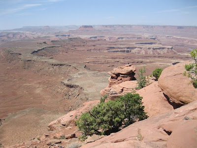
Road 169 ends at the rim and there are wide views north over Lockhart Basin. This is the terrain that is visible from the Needles Overlook and some of the other viewpoints in the Hatch Point area. The Colorado River winds through the area below but I couldn’t see it from this angle.


It took me 1:30 hours to arrive at the overlook. Without the side trail the main road distance is 3.8 miles. The return hike took 1:15 hours. My total hike took 3:00 hours for about 8 miles on a 44 F degree mild early January day. I didn’t see anyone else on this route while I was hiking. There were a few other vehicles in the area, including a few heavy trucks at a drilling site.