Sunday, December 5, 2010

Intrepid Trails at Dead Horse Point

The Intrepid Trail System explores the north section of Dead Horse State Park in southeast Utah. The access to Dead Horse Point is Utah Route 313, an east turn on the way to the Island in the Sky District of Canyonlands National Park. The most famous views in the park are at the Dead Horse Point at the south end of the park.

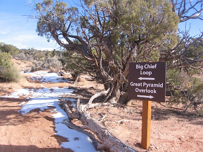
The trailhead is at the north end of the Visitor Center parking lot. There is a short 15 point interpretive trail around the visitor center that provides an introduction to the desert environment that the Intrepid Trail explores. The inner loop of the trail system is the 1.1 mile Intrepid Loop and the next loop is the 4.2 mile Great Pyramid Loop. The outermost loop is the 9 mile Big Chief Loop.
 
The first segment has two parallel trails, one for mountain bikers and hikers, and the other closer to the rim segment for hikers only. The hikers only segment passes though a sandstone pothole area where the potholes were filled with frozen over water. These potholes are important for the wildlife that lives in the area.
 
About 0.5 miles along the route there is a marked Colorado River Overlook point. There is a glimpse of the entrenched Colorado River deep in the canyons, about 2000 feet below. There are also views along here of the evaporation ponds of the Potash industrial activity in the canyon bottom.
 

It took me about 0:40 minutes to arrive at the Great Pyramid Overlook. The cliff forming layer at Dead Horse Point is the Wingate Sandstone, and the cap rock layer is the Kayenta Sandstone. 


The staircase rocks below the cliffs are the Chinle formation. Other layers visible here are the Moenkopi and Cutler, and the Colorado River flows on the Honaker Trail Formation.


The trail junction with the Big Chief Loop is about 0.5 miles further. At the junction, a hiker can loop back to the Visitor Center or continue on the longer loop. I continued, skipping the connecting segment. I hiked on a 40 F degree early December day. There were a few patches of snow along the way but the trail was mostly dry and easy to follow. (The Big Chief Loop is continued on the next post, or use the labels.)

18407_$5 Shipping on Orders of $99 or More! 544544_$20 off any hotel booking of $350 or more with code TLSALE20

Friday, December 3, 2010

Big Chief Loop at Dead Horse Point

The Big Chief Loop Trail is the outer loop of the Intrepid Trail System at Dead Horse Point State Park in southeast Utah. Dead Horse Point sits to the east of the Island in the Sky District of Canyonlands National Park. The access is along Utah Route 313, an east turn on the route to the Island in the Sky. Some of the best views of the canyon entrenched Colorado River are available at Dead Horse Point.

The main trailhead for the Intrepid Trail System is at the north side of the Visitor Center parking area. The inner nested loops are the 1.1 mile Intrepid Loop and the 4.2 mile Great Pyramid Loop. There is also a trail access at the Group Camping site. It took me about 1:00 hour of hiking to arrive at the trail junction for the Big Chief Loop following the route counter clockwise.
 

The Big Chief Loop veers away from the canyon rim and cuts through the high desert Pinyon Pine and Utah Juniper forest. Other plants common along the trail include Mormon Tea, Black Brush, Cliff Rose, Prickly Pear Cactus, and Yucca.


After another 0:30 minutes through the forest, Big Chief Canyon comes into view. A long west leading segment continues close to the south rim. The trail is mostly level and easy to follow. It is designed for hikers and mountain bikes.

Much of the trail is marked with dead branches or rock cairns. The day I walked there were some patches of snow that showed tracks of some of the animals that are active in late fall. The route has several signs along the way with maps that tell you where you are. All the trail junctions are well marked.


All along the segment leading to the Big Chief Overlook there are many views to the east toward the LaSal Mountains and the many fins of the Behind the Rocks area. The Potash industrial site is also visible at the canyon bottom.


The official overlook point is at a slightly higher point than the trail leading west along the canyon rim. The return segment leaves the canyon rim area and has views to the west across grassland. The return segment passes the Group campsite.

My total hike took 3:30 hours for the 9 mile loop. I hiked on a 40 F degree early December day and I didn’t see any other hikers and very few other park visitors despite the reasonable conditions.