Sunday, December 5, 2010

Intrepid Trails at Dead Horse Point

The Intrepid Trail System explores the north section of Dead Horse State Park in southeast Utah. The access to Dead Horse Point is Utah Route 313, an east turn on the way to the Island in the Sky District of Canyonlands National Park. The most famous views in the park are at the Dead Horse Point at the south end of the park.

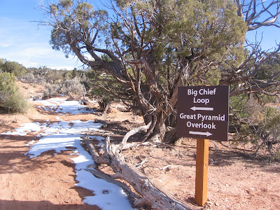
The trailhead is at the north end of the Visitor Center parking lot. There is a short 15 point interpretive trail around the visitor center that provides an introduction to the desert environment that the Intrepid Trail explores. The inner loop of the trail system is the 1.1 mile Intrepid Loop and the next loop is the 4.2 mile Great Pyramid Loop. The outermost loop is the 9 mile Big Chief Loop.
 
The first segment has two parallel trails, one for mountain bikers and hikers, and the other closer to the rim segment for hikers only. The hikers only segment passes though a sandstone pothole area where the potholes were filled with frozen over water. These potholes are important for the wildlife that lives in the area.
 
About 0.5 miles along the route there is a marked Colorado River Overlook point. There is a glimpse of the entrenched Colorado River deep in the canyons, about 2000 feet below. There are also views along here of the evaporation ponds of the Potash industrial activity in the canyon bottom.
 

It took me about 0:40 minutes to arrive at the Great Pyramid Overlook. The cliff forming layer at Dead Horse Point is the Wingate Sandstone, and the cap rock layer is the Kayenta Sandstone. 


The staircase rocks below the cliffs are the Chinle formation. Other layers visible here are the Moenkopi and Cutler, and the Colorado River flows on the Honaker Trail Formation.


The trail junction with the Big Chief Loop is about 0.5 miles further. At the junction, a hiker can loop back to the Visitor Center or continue on the longer loop. I continued, skipping the connecting segment. I hiked on a 40 F degree early December day. There were a few patches of snow along the way but the trail was mostly dry and easy to follow. (The Big Chief Loop is continued on the next post, or use the labels.)

18407_$5 Shipping on Orders of $99 or More! 544544_$20 off any hotel booking of $350 or more with code TLSALE20

Friday, December 3, 2010

Big Chief Loop at Dead Horse Point

The Big Chief Loop Trail is the outer loop of the Intrepid Trail System at Dead Horse Point State Park in southeast Utah. Dead Horse Point sits to the east of the Island in the Sky District of Canyonlands National Park. The access is along Utah Route 313, an east turn on the route to the Island in the Sky. Some of the best views of the canyon entrenched Colorado River are available at Dead Horse Point.

The main trailhead for the Intrepid Trail System is at the north side of the Visitor Center parking area. The inner nested loops are the 1.1 mile Intrepid Loop and the 4.2 mile Great Pyramid Loop. There is also a trail access at the Group Camping site. It took me about 1:00 hour of hiking to arrive at the trail junction for the Big Chief Loop following the route counter clockwise.
 

The Big Chief Loop veers away from the canyon rim and cuts through the high desert Pinyon Pine and Utah Juniper forest. Other plants common along the trail include Mormon Tea, Black Brush, Cliff Rose, Prickly Pear Cactus, and Yucca.


After another 0:30 minutes through the forest, Big Chief Canyon comes into view. A long west leading segment continues close to the south rim. The trail is mostly level and easy to follow. It is designed for hikers and mountain bikes.

Much of the trail is marked with dead branches or rock cairns. The day I walked there were some patches of snow that showed tracks of some of the animals that are active in late fall. The route has several signs along the way with maps that tell you where you are. All the trail junctions are well marked.


All along the segment leading to the Big Chief Overlook there are many views to the east toward the LaSal Mountains and the many fins of the Behind the Rocks area. The Potash industrial site is also visible at the canyon bottom.


The official overlook point is at a slightly higher point than the trail leading west along the canyon rim. The return segment leaves the canyon rim area and has views to the west across grassland. The return segment passes the Group campsite.

My total hike took 3:30 hours for the 9 mile loop. I hiked on a 40 F degree early December day and I didn’t see any other hikers and very few other park visitors despite the reasonable conditions.


Thursday, April 15, 2010

Colorado River Overlook Trail

The Colorado River Overlook Trail is the 4WD and bike trail that heads north from the Visitor Center at the Needles District of Canyonlands National Park in southeast Utah. The total trail length is about 7.5 miles one way.

                              
I drove the first 3.1 miles to a point where there is a rocky climb and the driving is clearly more difficult and began hiking there. The first 3.1 mile segment is sandy dirt road and was drivable in a Subaru. Above the rocky climb the dirt road resumes and stays mostly level along mesa tops and canyon rims.

There are several other areas along the trail with rocky sections and difficult driving. I saw a couple of spots where cement has been added to make the route smoother. On the day I hiked I only saw two mountain bikers and no vehicles on the trail. In the first mile of the 3.1 mile segment, there is one parking spot marked off on the narrow road, but it is not obvious what the attraction is there.

                                                                                                                                                                  
Hiking west through desert country the vegetation is Mormon Tea, maybe Blackbrush, Narrow Leaf Yucca, Indian Grass, Prickly Pear, with a few scattered Utah Junipers and Pinon Pines.


Unlike many Canyonlands hikes, there are 360 degree views along here toward the Island in the Sky, the Canyon Rims Needles Overlook, and back toward the Needles formations. Two large mesas in the Island in the Sky area stand out.


The Colorado River overlook area is unfenced and there is a warning sign to be careful. The Canyon is probably about 1000 feet deep here and the brown water moves slowly. I couldn’t see much vegetation along the banks and the rock layers are very steep. From the end of the trail there is a level area below that has views up and down river, and there are some rocky knobs to scramble over for slightly higher views.

Slightly to the south, scrambling over the white sandstone knobs, there is also a view into Big Spring Canyon as it makes a junction with the Colorado River. There is a monument formation similar to the ones visible from the Grand View lookout point in Island in the Sky.

It took me 1:45 to walk the 4.4 miles from the startpoint  to the Colorado River Overlook. My total hike for 8.8 miles took 4:00 hours on a 60 F degree mid April day. I carried 3 liters of water and drank 2 of them.
544544_$20 off any hotel booking of $350 or more with code TLSALE20

Tuesday, March 30, 2010

Wilhite Trail

The Wilhite Trail is a 6.1 mile route with 1600 feet elevation change in the Island in the Sky District of Canyonlands National Park in southeast Utah. The trailhead is west along the Upheaval Dome side road.


The first segment of trail crosses a section of the mesa top Island through scattered Pinon Pines and Utah Junipers. There is one point with a good view toward the Green River canyon with the Henry Mountains rising above the Wingate sandstone cliffs. The trail is heading for one of the few gaps in the Wingate cliffs that allow a descent. There are six long trails in the Island in the Sky that travel from the the grassy mesa top to the White Rim Road that circles around below.


The descent through the gap in the cliffs is scary looking from both the top and the bottom. The upper switchbacks are gradual and easy walking, but further down there is some minor scrambling.


The going is slow through this section whether descending or climbing, but the views are spectacular. The route through the jumbled rocks is well marked with rock cairns.


At the bottom the trail turns south and works along another canyon rim, coming very close to the edge in some places. Candlestick Tower is in view for the rest of the hike.

This segment is about 1 mile before the trail turns west and makes a final descent to the red Martian looking surface below.


Looking back toward the north, there is a large alcove visible. The different layers of sandstone in this part of Canyonlands are clear here. The massive Wingate cliffs seem to dive down, as does the ledgy Kayenta layer. The smooth layer on top is the Navajo sandstone, the same as the nearby Whale Rock Trail. The whole sequence sits on top of the softer shale and mudstone Chinle layer.

The view from inside the alcove toward Candlestick Tower is a favorite of photographers and features an Indian ruins circle of stones that is known as the False Kiva. There is an obscure trail leading into the alcove that is not mentioned on park maps and seems to be somewhat jealously guarded, in the name of preservation, by those who know where it is. The ruins are similar to the circle of stones that are along the Aztec Butte Trail, but it is the view in combination with the stone circle that seems to be special.

I turned around at the point where the trail makes the descent to the floor of Holman Springs Basin, near a large boulder. It took me about 2:30 hours to get to this point, about 3 miles down the trail. The rest of the trail doesn’t look as interesting for a day hiker, though the side canyons might be good for a backpacker to explore.

It took me 3:00 hours to return to the trailhead for a total hike of 5:30 hours for about 6 miles. I carried 3 liters of water and drank most of it on a 60 F degree late March day.

544544_$20 off any hotel booking of $350 or more with code TLSALE20

Tuesday, March 23, 2010

Syncline Loop Trail

The Syncline Loop Trail is an 8.3 mile circuit around the Upheaval Dome in the Island in the Sky District of Canyonlands National Park in southeast Utah.


The Upheaval Dome is one of the most interesting features in Canyonlands and may be the remains of a 500 to 1000 foot meteor strike that occurred 60-160 million years ago. The alternate theory is a salt bubble rose and deformed the area. There are interpretive signs discussing the alternate theories on the Upheaval Dome Overlook Trail.


The Syncline Loop crosses the Upheaval Dome Trail a few feet from the trailhead. I turned left but hikers can go either way. Turning left and following around clockwise puts the wide views more in front of you. The descent going clockwise has many switchbacks and is much like walking down stairs. It looks like some of the rocks have been arranged to make the footing easier. Large sandstone outcrops highlight the scenery.

Near the trail beginning there is a sign warning that the trail is strenuous and may be difficult to follow. The 1300 feet of elevation change makes the hike fairly strenuous but it is also well marked with rock cairns and isn’t hard to follow. The upper segment of trail is Pinon Pine and Utah Juniper Forest with the common desert shrubs including Mormon Tea, Prickly Pear and Barberry.


It is 3.4 miles to a signed junction with the Upheaval Canyon Trail that makes a left turn and leads down canyon 3.5 miles toward the White Rim Road and the Green River.
Staying on the Syncline Loop Trail it is another 0.3 miles to the 1.5 mile Crater Spur Trail that makes a right turn and explores the interior of the Upheaval Dome.


The Loop Trail doesn’t have any rim views into the Upheaval Dome crater, so this side trail is the only place to view the interior. This low area of the trail follows a dry wash and vegetation is very sparse.

I met some returning backpackers who had traveled further down canyon and had visited a ruins site near the river. The clockwise route is a shorter distance to the bottom trail junctions and looked to be an easier climb for those carrying a heavy pack.
The trail segment that starts to climb back up the Syncline Valley has some pools of water in the creek and has quite a bit of rock scrambling. The scrambling section is about the midway point of the loop hike.


There is one spot where steps have been carved. There were the remains of some metal bars next to the steps. This might have been a formerly difficult spot that has been made easier. I thought this section seemed a little more slippery with loose material than other parts of the trail.
After the scrambling section, the trail continues to climb but only gradually. In mid March, an always shady segment along the Syncline Creek still had a large snow patch on an otherwise mild day. The 4.6 mile north section of the loop stays in the canyon and doesn’t have any wide views.

My hike took 5:15 hours for the 8.3 miles. I carried 2 liters of water on a 55 F degree mid March day, but I think 3 liters would have been a better choice. I met two groups of hikers taking the counter clockwise route, a group of 2 and a group of 8.


18407_$5 Shipping on Orders of $99 or More! 544544_$20 off any hotel booking of $350 or more with code TLSALE20