Wednesday, September 24, 2008

Anticline Overlook Trail

The Anticline Overlook Trail is a short loop at the extreme north end of Canyon Rims Recreation Area in southeast Utah.
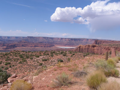
 The first view area is about 150 yards up the trail. This view area is to the east of the Island in the Sky District of Canyonlands National Park and Dead Horse Point State Park.

The view to the north finds the Colorado River winding through an area where the layers of rock have been bulged upwards, the curving layers obvious. From here there are also views of the potash mining ponds, large blue lagoons sitting among the red rocks.

Following the rocky loop trail clockwise, the view shifts from the Colorado River canyon to the Kane Creek Canyon. There is a rough looking road down below that crosses the Hurrah Pass from Kane Creek to the Colorado River side. The road isn't as rough as it looks from here. It is possible to easily drive and hike there.

In the extreme distance an arch is visible. My guess is that it is the South Window in Arches National Park.

Following around and looking southeast the La Sal Mountains loom over more of the Kane Creek Canyon. The overlook trails here are well equipped with guard fences and numerous benches to enjoy the overwhelming views.


528614_Cool Camo Russell Outdoors

Monday, September 22, 2008

Minor Overlook Trail in Canyon Rims


The Miner Overlook is a short gravel loop around a large rock outcrop and provides vews of the Colorado River in Canyon Rims Recreation area in southeast Utah. It is named for Park Service Worker David Minor who worked for many years in this area.

This view point looks to the west towards Dead Horse Point State Park and the Island in the Sky District of Canyonlands National Park. The views of the Colorado are as good or better than from those two more famous viewpoints.
To the northwest there is a view of the Potash Mining activity. Colorado River water is pumped into the salt bed underlying the rock formations here, then returned to the surface and evaporated, leaving the raw product.

The train tracks that carry the material to market are visible near Arches National Park and along Potash Road near Moab.
Most of the attention here is directed west toward the Canyonlands area but there also good views to the east of the nearby LaSal Mountains.

Sunday, September 21, 2008

Wineglass Arch Trail

The Wineglass Arch is a short distance off the main road, close to the Anticline Overlook at the north end of Canyon Rims Recreation Area in southeast Utah. It is one of about 50 reasonably large arches south of Moab and outside of Arches National Park.

The Wineglass Arch is visible from the road. There are some trail segments, but it is easy just to cross the open field to the base of the rock outcrop. If you spend enough time in this area, I think you become more interested in becoming an arch spotter, taking time to see these small but otherwise rare formations.
Glancing up as I made my way toward Wineglass, there is a second arch about 100 feet to the north. Not a famous arch, but it appears to meet the three foot opening standard and qualifies.

Since there were two arches here, I continued around the backside of the formation looking for more, but I didn't see any.

Saturday, September 20, 2008

Needles Overlook Trail

The Needles Overlook Trail is a short loop route in the Canyon Rims Area of southeast Utah that features very wide views of the Canyonlands National Park area of the Colorado River.The view to the north shows the massive Wingate sandstone cliffs and some glimpses of the blue Colorado River as it twists through toward its entrance to the Canyonlands Park area.
There are smooth easily accessible portions of the trail, but much of it is over the rough natural terrain of this rocky point. The terrain below the safety fence is a baked reddish surface that looks hostile, but has a lonely road snaking through it.
The view to the west is across Indian Creek toward the Needles District of Canyonlands, where the carved rock spires are visible. There is almost more scenery here than one can absorb.
To the south, the green ribbon of Indian Creek approaches. Indian Creek starts in the Blue Mountains where there is a trail following it out of the mountains.

It flows past the Newspaper Rock petroglyph site and parallels the road to the Needles District, then cuts through this area on its way to join the Colorado River.

Friday, September 19, 2008

Armijo Arch Trail

The Armijo Arch Trail is an unofficial route following one of the many side roads in Canyon Rims Recreation Area in southeast Utah. The Canyon Rims area features terrain similar to nearby Canyonlands National Park.


I found a place to park near a small gravel pit that is about 2.3 miles past the Wind Whistle campground. The 4WD road trail connects to the main road about 100 feet south. The information on this hike comes from "Natural Arches of the Moab Area (South) " by Chris Moore. There is no specific information for this hike in the park area though visitors are encouraged to explore on their own.

After about 1.8 miles and about 40 minutes the road ends at a canyon rim. I think the area below is called Hart's Draw, but it looks like a very impressive canyon. To the south the Blue Mountains near Monticello, Utah dominates. The cliffs below this overlook spot are very steep.


The Armijo Arch is visible to the north as an alcove at the top of the reddish sandstone layer and just below the white sandstone layer. From this angle you can't see any light through the opening.


It is possible to move north along the rim follow some cattle trails, get down to a lower level and get a closer view up to a point where the drop off gets scary.


Even at closer range the opening is not visible. Apparently the opening is from the top and you have to get below and view upwards. It looked to hazardous to go any further. It took me 1:40 hours to make this about 4.0 mile walk.

Thursday, September 18, 2008

Windwhistle Interpretive Trail

The Windwhistle Trail is a 0.5 mile interpretive loop located at the Wind Whistle Campground in the Canyon Rims Recreation Area in southeast Utah. Canyon Rims is a large area that sits to the east of Canyonlands National Park.

The trail winds through a pocket surrounded by a large sandstone formation. Water flowing off the rocks and the sheltered position seems to make this a rich area for local plants. The trail guide names 28 different plants at numbered stops.

There are several here that other botany trails in the region don't usually have. The Fremont Barberry has edible fruits eaten by wildlife and man. It has small shiny green holly like leaves that remain on the plant through the winter. I hadn't noticed this plant in other parts of the region.

Nestled high in a sheltered shady corner are a couple of Douglas Firs. These are usually high elevation mountain forest trees, but they survive here in a cool and moist micro climate. This view also shows slightly different sandstone layers with different patterns of erosion.

The Singleleaf Ash is unlike other ashes in having only a single leaf rather than three to seven leaflets per leaf. Wildlife eats the seeds and early settlers used the tough wood for tool handles.

False Mockorange grows in rock crevices and is in the Saxifrage Family along with Gooseberries, currents, and hydrangeas. Wildlife will browse the leaves when other plants are scarce. This short trail is a good introduction to the vast space of the Canyon Rims Area.