Tuesday, October 11, 2011

Lower Monument Canyon Trail-Colorado Nat. Monument

The Lower Monument Canyon Trail is one of the backcountry trails in Colorado National Monument in western Colorado. The trailhead is not along the main Rim Rock Drive. From the west entrance, continue east along Highway 340 for about 2 miles. There is a small sign for the trailhead and the entrance looks like you are entering someone’s driveway.

All the Colorado National Monument trails have good trailhead maps and information signs. The Monument Canyon Trail allows views of the large eroded formations that most visitors view from the Rim Rock Drive. The total trail is 6 miles to the Coke Oven Trailhead, with a climb from 4700 feet at the trailhead to 6140 feet at Coke Ovens. I hiked the 2.4 miles to Independence Monument with a climb from 4700 feet to 5289 feet.
The first 15 minutes of hiking seems odd in that the trail follows the park fence line. There is wilderness on one side and suburban living on the other. The overly large fence may be for the bison that once were here. The bison have been removed and now there is a healthy herd of mountain sheep roaming the park.

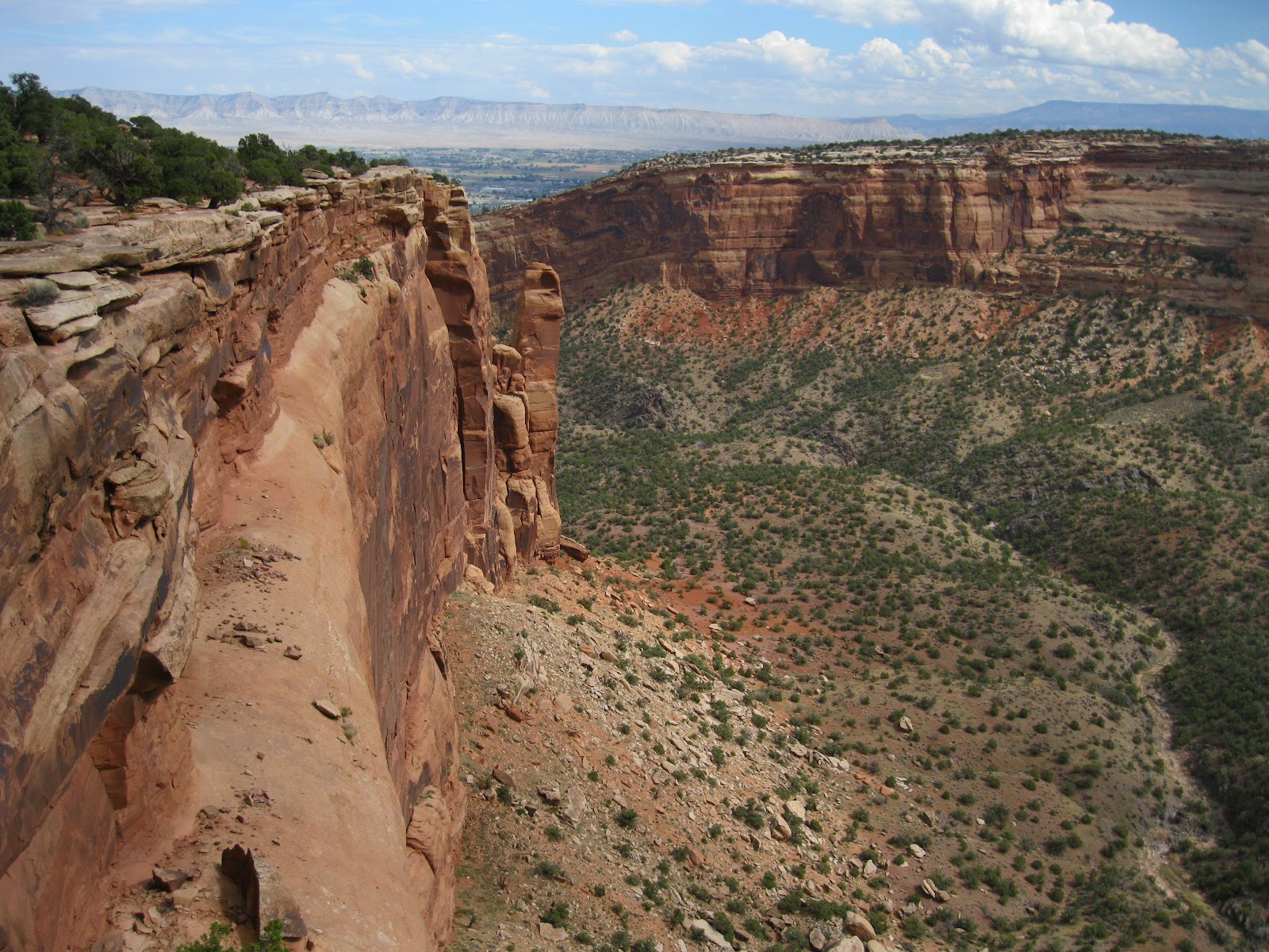
After entering Monument Canyon, the trail hugs the contours along the right side of the canyon, climbing steadily. The trail is improved with carved steps. Most of the climbing is along this segment.

The first named formation that comes into view is the Kissing Couple. The upper part of the Monument Canyon Trail passes around the Kissing Couple and heads up the canyon to the left.

When the views east open up, the Pipe Organ and the Praying Hands are visible. These formations are below the point that Otto’s Trail visits.

The route approaches the north side of Independence Monument. The trailhead map shows the unimproved Wedding Canyon Trail junction here but the junction isn’t marked with a sign and wasn’t otherwise obvious. The Wedding Canyon Trail loops back to the Lower trailhead for a 4.7 mile hike. The junction close to the trailhead wasn’t marked but was obvious.

It took me 1:30 hours to arrive at Independence Monument where I turned around. I hiked on a cloudy 65 F degree early October day and caught a few sprinkles of rain. I carried and drank 2 liters of water. My downhill return hike on the main trail took 1:00 hour for a total time of 2:30 hours for 4.8 miles.


544544_$20 off any hotel booking of $350 or more with code TLSALE20

Sunday, October 9, 2011

Dinosaur Hill Trail-Fruita, Colorado

The Dinosaur Hill Trail is the site where the bones of a 70 foot long and 30 ton Apatosaurus were found in 1900. This skeleton is famously displayed at the Chicago Field Museum of Natural History. The Apatosaurus was formerly called the Brontosaurus.

The trailhead is located on Route 340, just south of Fruita, in western Colorado. This site is on the way to the west entrance of Colorado National Monument. There are numbered stops along the 1 mile loop trail but I didn’t find a printed trail guide. There are several interpretive signs that tell the story. Dinosaur Hill is one of the Dinosaur Diamond attractions.

The highlight of the trail is the quarry where Elmer Riggs excavated in 1901. The tunnel was reopened in 1991 and several tools and additional bones were found.

In 1938, Elmer Riggs returned to Dinosaur Hill for the installation of the commemorative plaque by the Grand Junction Chamber of Commerce. This plaque is mounted next to the quarry.

From the top of Dinosaur Hill, there is a view of the nearby Colorado River. One of the interpretive signs discusses the logistics of moving the 6 tons of dinosaur bones from the quarry to Chicago in the early 1900s.

At the trailhead, replica thigh bones have been installed as benches. The replicas are based on photographs of the actual bones. I visited on a cloudy 65 F degree early October day. There are several more dinosaur related sites to visit in the area.

528614_Cool Camo Russell Outdoors

Saturday, October 8, 2011

Canyon Rim Trail-Colorado Nat. Monument

The Canyon Rim Trail is a 1 mile roundtrip along the canyon rim at the Visitor Center of Colorado National Monument in western Colorado. The Visitor Center is close to the west entrance of the park.

Colorado National Monument is celebrating 100 years of service in 2011. The Monument was established in 1911 mainly through the efforts of early resident John Otto.

The early views across Wedding Canyon are toward the formations called the Pipe Organ and the Praying Hands. The short Otto’s Trail travels out to the point for a closer view of those formations. The Independence Monument comes into view as you get further out along the trail.

The view down the canyon includes the Fruita and Grand Junction area. These are Wingate sandstone cliffs with the Kayenta layer forming the cap layer. The vegetation here is Pinon Pine and Juniper forest with desert shrubs.
At the end of the trail is the Window Rock formation. From here a hiker can backtrack to the Visitor Center or loop back along the campground road, which has slightly higher views.

The 1 mile round trip Alcove Nature Trail also begins at the Visitor Center along with the long backcountry Black Ridge Trail. The Alcove Trail has a trail guide to 31 marked stops.

The marked stops emphasize the geology and erosion features and the plants and animals that live here. The rock wall along the trail is Entrada Sandstone sitting on Kayenta Sandstone. There are examples of cross bedding pointed out along with carbonic acid caused cavities.

Friday, October 7, 2011

Otto’s Trail-Colorado Nat. Monument

Otto’s Trail is a 1 mile round trip to an overlook of Monument Canyon in Colorado National Monument in western Colorado. John Otto moved into this area in 1906 and it was his campaign that led to the formation of Colorado National Monument in 1911.

John Otto was the first caretaker of the Colorado National Monument and worked hard building trails to make the area accessible. Otto’s Trail begins at 5800 feet elevation and descends gradually through Pinon Pine and Juniper forest.

The view directly ahead at the overlook is toward the formations called the Pipe Organ and the Praying Hands.

To the right is a view of the Independence Monument. Back on the Rim Rock Road there are more views at Independence Monument Viewpoint.


The interpretive sign explains the ways that erosion can vary, causing these formations. John Otto made the first recorded climb to the top of Independence Monument.

The Grand View Viewpoint also has good views of all these formations. The Monument Canyon Trail at the Coke Ovens Trailhead provides access to the area around the base of Independence Monument.


528614_Cool Camo Russell Outdoors

Thursday, October 6, 2011

Coke Ovens Trail-Colorado Nat. Monument

The Coke Ovens Trail is a 1 mile round trip to a Coke Oven formations close-up overlook in Colorado National Monument in western Colorado. The trailhead is 3.8 miles east of the Visitor Center along the Rim Rock Drive.
There is a Coke Oven overlook point along the Rim Rock Drive a short distance west of the trailhead that provides a good profile view. The Coke Ovens are sandstone with a hard cap that protects part of the sandstone. Where the cap breaks, the sandstone has eroded into a rounded shape.

The trailhead for the Coke Ovens is also the starting point for the backcountry Upper Monument Canyon Trail. The two trails use the same switchbacks for a short distance, and then split at a well marked junction. The Coke Ovens Trail stays along a ledge while the Monument Canyon Trail continues to descend. The starting elevation is 6140 feet and there is a 160 foot descent to the lookout point.


There is a fenced overlook at the end of the trail. The view of the Coke Ovens is from the end of the line.

Looking into the canyon from the left side of the overlook, the route of the Monument Canyon Trail can be viewed. The trailhead map says it is 3.5 miles one way to the Independence Monument on the canyon floor.

Wednesday, October 5, 2011

Devil’s Kitchen Trail-Colorado Nat. Monument

The Devil’s Kitchen Trail is a 1.5 mile round trip to a rock grotto in the canyon country of Colorado National Monument in western Colorado. The trailhead is 0.2 miles from the east entrance. The west entrance is the easiest to find for visitors and this hike is at the end of the 23 mile Rim Rock Drive.

Four other trails begin at this same trailhead, two long back country routes and two shorter trails. The trailhead maps and information signs at Colorado National Monument are very good. The trailhead elevation is at 4990 feet. The trail junctions are well marked with directions and distances for the various options. The terrain is desert vegetation along a canyon floor with towering sandstone canyon walls.

The sandstone layers are the familiar Wingate, Kayenta, and Entrada that are visible in many of the rugged canyon areas of the Colorado plateau. The Navajo sandstone layer seems to be missing. The vegetation is the Pinon Pine and Utah Juniper forest with desert shrubs like Rabbit Brush and Mormon Tea. I think a saw some single leaf ash trees along the way.

It is a modest 200 feet of elevation change climb up to the Devil’s Kitchen on some carved steps. I could see some side trails in this area. I scanned the cliff faces with binoculars for rock art, but didn’t see anything from the distance.
The Devil’s Kitchen is the partially enclosed space between some high sandstone towers. There is a small window or arch high on the inside. The Devils Kitchen Trail took me about 0:50 minutes. I hiked on a cloudy 65 F degree early October day late in the afternoon.